Showing posts with label Cross Country. Show all posts

Monday, May 11, 2015

Another’s Inspirational Odyssey

A friend of mine still in her 20s living in Durham is a kindred spirit of sorts.

She has that blend of discoverer and deliverer that is the foundation for entrepreneurial spirits who are able to build and sustain innovative organizations.

She, too, sort of backed into her career and like I was at her age, curious about why she has so quickly been labeled an innovator.

Recently, I shared with her some of the kindred spirits who reached out to me when I arrived in Durham 26 years ago to build and grow what would be my fourth start-up in a long ago concluded career in a field different from hers.

I’ll share who they were in another essay some day, but like I am to her, they were old enough to be my grandparents.  I guess innovators can identify one another across generations.

But I wonder if one of my young friend’s early influences was her decision after college to bicycle with some friends on a route from coast to coast.

Let me explain why such a trip should also be a job requirement for anyone hoping to be involved in community destination marketing, as I was.

My friend and her companions biked east to west roughly following the old Bikecentennial route pioneered 40 years ago by a handful of other entrepreneurial innovators.

Back then, more than 4,000 cyclists to bike took part in portions of the route during the summer of 1976, 2,000 of whom completed the entire journey.

That was the year after I took the helm of my second startup, the first truly as the executive and a full-fledged community marketing organization.

By 1978, as I headed to Anchorage to complete another startup, the Bikecentennial had inspired AASHTO to recognize the existence of what is becoming a national system of bicycle routes.

It was an endeavor that would span the remainder of my career and beyond.  Today, 8,043 miles have been established involving 16 states with 40 states overall working on various routes.  Propelling it to its completion is still that original startup.

The transcontinental route my friend took is a slight variation of what is now U.S. Bicycle Route 76.

I was surprised to learn that the toughest mountainous segment was not the 68.6 mile, 3,341 ft. climb from Fort Collins over the 8,063.45 ft. pass on the southern route to Laramie.

Nor was it climbing over the Continental Divide in the Wind River Mountains or up along my native Tetons or then across the Bitterroots or up over the mile-high Lolo pass and through the canyons of the Clearwater.

It was just north of Durham in the southwestern Virginia portion of the Appalachians where, the Messersmiths, a line of my ancestors, had settled in the 1700s before heading west.

It was the hardest segment, not just because it was only a few days into their ride but, because the roads were so windy and the grades so much more difficult.

But the toughest portion of the whole journey was the relatively flat variation on the route they took down the Washington state side of the Columbia River Gorge before crossing over to Portland, due to riding against the wind blowing up the Gorge from the Pacific that makes it a haven for windsurfing.

When you discuss routes to the coast in Oregon, people usually refer to them in relationship to a series of colleges stretching down I-5.  Cannon is across from Portland State and Lewis & Clark College.

The beach at Lincoln City is across from Willamette University in Salem where I started law school.  Newport Beach is across from Oregon State in Corvallis.

UBR 76 ends at Florence Beach, across from the University of Oregon in Eugene but my friend’s more than 4,000 mile ride ended on Cannon Beach with its picturesque Haystack Rock.

These beaches are seared into my memory just as they were on 9/11 during a visit.  I first saw news about the initial plane crashing into the World Trade Center as I came in from watching the fog at Bandon.

It was eerie driving up the coast along each of these beaches on a bright, sunny day.  Each of these little towns almost seemed deserted including during an overnight at Cannon Beach.

Hearing about her journey across Kansas reminded me of the jestful lyrics to a song entitled Nickels Worth of Difference:

“There ain’t a nickels worth of difference in Kansas and Nebraska

A lot of wide open spaces, every now and then a tree

But I suppose if you were born and raised around there you might beg to differ

Yeah but I’m from Oklahoma, it looks pretty much the same to me”

While singer-songwriter Tom Skinner was playing off the ribbing that goes on between states, he puts his finger on how geographic stereotypes can predisposition some of us to miss distinctions.

They are clear as you drive cross country in a Jeep as my English Bulldog and I have along various routes at least eight different times since I retired.  I can only imagine how much more clear they are when viewed from a bicycle or walking.

Research shows that the vast majority of us are drawn to these distinctions when we travel while a much smaller share is drawn to places that look and feel indistinct or to replicas of where they live.

It is a bit like the difference that distinguishes the small number of executives who are “innovator-deliverers” from the vast majority who, as just “deliverers,” ultimately create stagnation.

In sense-of-place parlance, it is the difference that distinguishes “stayers” who safeguard the communities in which they live from “boomers,” otherwise reasonable people who lacking those sensibilities seem to trample or homogenize it instead.

I’m getting the itch for another cross-country trip with Mugs.

Wednesday, March 25, 2015

Thoughts From A Roadside

Several thoughts raced through my mind yesterday while viewing the roadside of a freeway interchange in Durham, North Carolina, where I live.

These parcels are very park-like when well-maintained, as members of a public-private coalition called Durham Appearance Advocacy Group (DAAG) is trying to do by forging alliances between local governments, businesses and groups such as garden clubs and Scenic North Carolina.

The one we discussed yesterday is meant to serve as a template for every interchange in Durham.

But ironically, regressives in the State Legislature have been working at odds, filing bills to disable state management of these roadsides and permitting out-of-state billboard companies to wantonly deforest them in order to prop up an obsolete technology few Americans use now.

Now they have even filed a bill, with an innocuous misleading intro, meant to override wildly popular democratically enacted bans on this form of desecration marketing and blight that have stood in communities such as Durham for more than three decades and ruled constitutional by the U.S. Supreme Court.

This tyranny by representatives not from Durham reminds me that revolutionaries founded our democracy not in opposition to taxes but due to corporate loopholes granted by the feudal systems of governance then in place.

In opposition at the time and ever since stood regressives trying to pull the country backwards.  One wonders, will another revolution soon be sparked?

In the 1930s, roadsides such as those I was standing alongside yesterday were already battlegrounds between the forces of blight and the forces of scenic preservations.  Jobs, jobs, jobs was the mantra then too but it was both/and when it came to scenic preservation.

Highway 100 was one of the first, if not the very first beltlines in the country.  It patched together a series of existing roads south and west of Minneapolis but included new construction of a stretch of more than 12 miles including what we now call clover leafs.

It was deemed the “Lilac Drive,” lined with 30,000 plants including 8,000 Lilac shrubs and 7 roadside parks.  It became a recreational destination and living proof that Americans are drawn to scenic character over commercial blight along their roadsides.

It was in the middle of nowhere back then but had the support of development interests and billboard companies eagerly pushing for sprawling suburbs that would soon gobble up acreage at a rate many times the rate of population growth, as it still does today in Durham.

Emily Badger reported in The Washington Post this week about a new study that that concludes that sprawl costs the U.S. economy now more than $1 trillion a year.

The reason deficit hawks are not licking their chops is that $400 billion of this is pushed off on other people, something economists call negative externalities, which is a fancy word to describe when the free market doesn’t incorporate its true costs.

Only a portion is found in inflated costs for public services.  We absorb the rest sometimes in our lungs and often while stuck in traffic, but all in all it is very similar to the tax loophole that led to the original Boston Tea Party.

Billboarders and their legislative allies aren’t the only ones who want to shift even more of those costs onto unsuspecting Tar Heels including millions of us “hard-working taxpayers” we so often hear regressives talk about.

Over the last five decades (1960s-2000s,) the NCDOT has carefully reforested and afforested more than 5 million trees along the state’s roadsides, in part, to mitigate for many times that number which had been destroyed during road constructions.

The trees were also meant to bolster a signature ingredient of North Carolina’s brand.

This included lining the state’s roadways with spectacular understory trees such as native Redbuds and Dogwoods, the state tree.  Then, without thinking, another unit enabled private maintenance contractors to destroy most of them just for their convenience.

During our cross-country road-trip a few months ago for my mom’s funeral, Mugs and I took I-64 through Saint Louis.  This included a 10 to 11 mile stretch through the heart of that area that had recently been rehabilitated.

Some even call it that community’s front door.

The area is sea of concrete and buildings leaving almost no roadside.  But the Missouri DOT has carefully carved tiny slivers of planting areas where possible along this stretch and recruited businesses and organizations as landscape sponsors.

It too, I suspect is meant as a pilot project for a more strategic approach going forward.  An example of the discreet but very visible signs erected for sponsors is shown as the image in this blog.

Research shows that less than a fraction of 1% of consumers still use billboards.  It takes less than six seconds to decipher one but consumers only give them an average of three, even when digitally flashing on and off intermittently to draw attention away from the road.

Yet billboard companies now want to deforest even interchanges in hopes that someone traveling past them or focused on exiting or merging onto the highway will have twice as long to look.

Yes, it is obscene and possibly the spark for another revolution, if not with torches, pitchforks or midnight rides, a roadside revolt.

Tuesday, February 10, 2015

Three Take Aways From Our Time On The Road

I rarely listen to sports talk radio unless I’m on a cross-country road trip such as the one my English bulldog Mugsy, and I completed last week.

Unrelated to sports, three things stood out to me from sporadically listening to those shows besides learning that “deflategate” involved only one football, not twelve as had been widely reported. 

Sports fans love conspiracies (e.g. the Seahawks called the last play to make sure a certain player was not the MVP had the team won.)

Now there is speculation that it was the Colts who deflated the one ball found to be underinflated after it had been in that teams possession, not the Patriots as alleged (smile.)

One of the things that caught my attention was an expert who explained how many people confuse confidence and arrogance.

This is a misperception that has often been made about me since high school and one that some fans make about Patriots Quarterback Tom Brady who led his team to four Super Bowl championships after not being drafted until the199th player chosen.

One of my favorite explanations of the difference between confidence and arrogance is one I read just before I retired by Harvey Mackay, the author of Swim With The Sharks Without Being Eaten Alive:

“Confidence in one's ability is a critical element in the willingness to take risks while still steering the ship. Arrogance takes risks by assuming everyone will get on board even when the boat has a hole in it.”

The second thing that caught my attention was something I’ve rarely  heard discussed publically among people who are black.  It was when Larry Foote, a middle linebacker for the Arizona Cardinals called Marshawn Lynch, the star fullback of the Seattle Seahawks, out for antics during the Super Bowl:

“I’m from the same type of urban environment that he’s from and the biggest message that he’s giving these kids, he might not want to admit it, is the hell with authority.

‘I don’t care, fine me, I’m gonna grab my crotch, I’m gonna do it my way.’ In the real world, it doesn’t work that way. It just doesn’t.

How can you keep a job. I mean, you got these inner city kids, they don’t listen to teachers, they don’t listen to police officers, principals and these guys can’t even keep a job because they say ‘F’ authority.”

It was the kind of introspective candor that would have given the protests related to events in Ferguson, Missouri during our cross country trip last summer so much more credibility among those who were skeptical.

But enough about sports.

The last observation that caught my attention was a hint of desperation by one talk show host when, with relief in his voice, he inferred that a drop in audience was due to younger listeners time-shifting with podcasts.

I was listening to those talk shows on satellite radio but often I would stream music via Pandora from my smartphone, and I wondered just how prevalent that has become via any of the music streaming services.

At our next overnight stop, I drilled down into the details of a study of music streamers (at least monthly) and non-streamers (use it less than monthly or not at all including non-music listeners.)

Non-streamers over-index to genres like country or folk or a combination such as roots music so I am in the minority there.

Music streamers, according to the study, are only slightly (63% to 61%) more likely to listen to music in their cars but far more likely to listen to music at home and three times as likely to listen to it while traveling, as I was.

Non-streamers are only comparable when listening to music on a computer.

Interestingly, Spotify commissioned the study to learn more about how streamers vs. non-streamers connect to brands.  It turns out that streamers are nearly twice as likely to feel emotionally connected to a brand and more importantly to be an advocate.

A separate tracking study by Blueshift Research shows that among music streamers, 40.9% use Pandora Free (which includes advertising,) 25.4% use YouTube, 11.8% use Spotify Free and iHeart Radio each and 10.3% use iTunes Free.

Only 2% in my age bracket pay to a fee to avoid the ads as I do.  Indicative of how fast streaming is being adopted as a music alternative to radio, only 31.7% have yet to access it.

That is now nearly the same percentage of Americans (30.6%) who do not pay for TV in their homes.  Many Americans, 38.7% of those ages 18-29, have never had pay TV service such as cable or satellite.

Of Americans who are cord cutters, 10.4% have shifted to streaming services such as Netflix and Hulu and 7.6% have reverted to free TV using an antenna.  The average streamer uses 2.3 services.

Even more interesting is that 60.5% of cord cutters are women including 21% with children younger than 5 living with them.  Some of this is due to how costly and inflexible pay packages became but a good deal has to do with advertising.

Traditional advertising is a form of “yelling” to get your attention rather than earning it.  Savvy parents know how unpredictably inappropriate much of this yelling is for young people.

Paid television, may soon be dominated, as sports talk radio is, by advertising relevant only to some adult males.

Every form of advertising has slipped since 2008.  Even garish digital billboards have not stopped the decline of outdoor advertising use, now relevant to less than 2% of consumers and known more for clear cutting roadside forests and desecrating views.

Online advertising, though, has increased during this span nearly 300%, most of that now as content-driven advertising, delivered not as interruption but there when you need it.

According to a new report by Borrell Associates, true digital advertising such as this has now grown to the “dominance newspapers enjoyed for years, until the late 1990s.”

We look at services such as Uber as disrupting the way we access vehicles for hire but according to analysts at BIA/Kelsey, they may be signaling a revolution in how we access all goods and services at the local level (aka ODLS or On-Demand Local Services.)

Nowhere is this change more relevant than to small and medium size businesses and organizations (SMBs.)  It is not just the final nail in the coffin for traditional advertising at any level but a revolution in marketing.

Monday, February 09, 2015

Grieving and Other Stereotypes

I didn’t drive cross country to my Mom’s funeral and back during the last two weeks to save money.  It costs a third or more than just flying and renting a car.

We all grieve differently and I knew the three and a half day drive out would give me time to do that before I got to Spanish Fork, Utah where she was buried.  It also provided as well, a chance to think through the overview of her life I would deliver at graveside.

In breadth, this essay will resemble our frequent conversations.

She was a few days short of 86 years old when she died.  Mom had battled the last couple of decades through macular degeneration in both eyes, a broken pelvis, hip and wrist as well as constant pain and/or feeling loopy from pain patches.

Always cheery, she had frequently told me she was ready to go, and in retrospect, for the past year there were signs she was coming in for a landing.

She had skipped the annual lakeside family rendezvous last summer and then let her apartment go to move north along Puget Sound to live with my youngest sister and brother-in-law.

She studiously used a “reader” to sort through all of her papers and mementos so they would be in order.

The first night of our trip out, Mugs and I stayed in Paducah, located in that far western tip of Kentucky pointed into a nook between Tennessee, Missouri and Illinois.

Mugs and I drove north the next morning up across the Ohio River as dawn began to break from just over my right shoulder.

I recalled reading Mom’s great-grandfather’s journal about a trip he made in 1840 up that river to visit his Quaker mother one last time before then heading west another 1,100 miles into the Rocky Mountains.

Also crossing my mind was my Mom’s parenting and love dating to my first memories of her singing ad reading to me,  Suddenly, my numbness gave way to tears that didn’t let up for several hours until we were well past St. Charles, Missouri.

The emotion was a mixture of sadness at her passing, joy remembering her life and relief that she was no longer in pain.  I also wondered if she was mad as hell to get to the afterlife and see my Dad there because he didn’t have to sit through all of those meetings at church (smile.)

I had driven the route before but never from the direction we travelled that morning nor at that time of day nor when I was so much in the moment.

Before stopping for the night in Salina, Kansas, I had been marveling at the stereotypes we are often given of various states and how some over deliver while others under deliver on those expectations.

The vast majority of Kansas over delivers.

Many people stereotype it as flat and ultra conservative including being rabidly anti-choice when it comes to a woman’s personal control over decisions about her body.

But those are just the aspects given the most exposure in news reports.

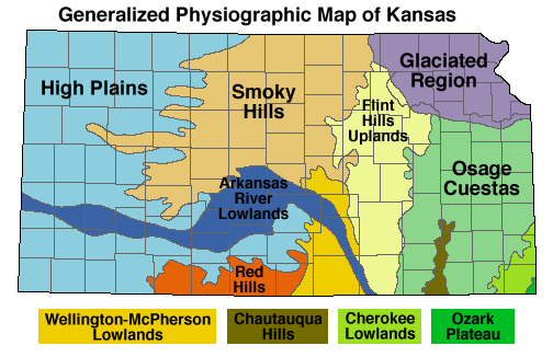
Of course, there is always some truth to stereotypes.  About a third of Kansas is indeed comprised of high plains, much like half of adjoining Colorado as well as a majority of Montana which escape that stereotype and a large corner of Wyoming, part of Nebraska and South Dakota and the panhandles of Texas and Oklahoma which don’t.

Stereotypes are never even handed.

Salina lies where the Flint Hills Uplands give way to the Smoky Hills region of Kansas, just north of the Arkansas River Valley.  It was an incredible 70 degrees the January evening I stopped there to overnight.

We drove west another two hours the next morning before getting into the high plains where they continued along our route for another four hours, mostly in Colorado before cutting north along the Rocky Mountain Front and then west to cross the Continental Divide at South Pass after our final outbound overnight in Rawlins, Wyoming.

Speaking of stereotypes, we’re also given to believe by the news media and politicians that Wyoming is incredibly conservative at 41.6%, the third highest in the nation.  But overlooked is that 40.2% of residents there self-identify as moderate and 13% as liberal.

Does a tiny 1.4% differential warrant a stereotype?  Jackson and Laramie certainly aren’t large enough for the majority of Wyomans, who in fact aren’t conservative, to be sequestered only there.

South Pass is a relatively low spot between the central and southern Rockies where beginning in 1847 in little more than a decade every line of ancestors on both my Dad and Mom’s side passed before becoming a union in our ancestral Yellowstone-Teton nook of Idaho where the central and northern Rockies meet.

Kansas also isn’t as conservative politically as politicians as well as those who plant those annoying little abortion signs along the freeway there hope to make you believe.

It is the 22nd most conservative state at 38.4% but the full story is that 36.3% of Kansans self-identify as moderate and more than a fifth as liberal, ranking it as average overall, just above North Carolina.

The signs along the Interstate there shout out warnings about abortion and call for stricter policies but surveys show that those messages represent the views of a minority of Americans and probably Kansans, too.

Even 19% of Republicans want them to be the same or less strict but a combined 45% of Independents and Democrats also feel that way.  Overall, only 24% of Americans support making them stricter.

Neither Salina nor Kansas existed in 1847 when three ancestors of my Mom’s marched just south of where that town would be founded a half dozen years later and just north of what would become Durham, Kansas, (smile) down along the old Santa Fe Trail with the Mormon Battalion  destined for the War with Mexico.

They exited what is now Kansas near what would later be named Liberal, Kansas which in that era meant “kind.”

Places and physiography as well as stereotypes get politicized over time.  Kansas for instance has a rate of 30% obesity among adults.  Is it found more commonly among those who are conservative or moderate?

Not sure what all of this has to do with my Mom who self-identified as a conservative, but in reality she was more moderate, except that this essay closely resembles the vast range of topics we would touch on during frequent phone calls.

Intellectual curiosity is a family trait.  So is a stiff upper lip.  So is grieving the way we do.

Miss you MomRed heart.  Please tell Dad hey.

Friday, January 16, 2015

A Spiritual and Economic Dividend

I was too distracted by the magnificence of the peaks towering ahead to pay much attention a few years ago when with Mugs, my English Bulldog and travel companion, we twice crossed the Two Medicine River.

So too, has most of the mainstream media, failed to notice two remarkable developments there recently.

That afternoon, Mugs and I were on one of our annual cross-country road trips to rendezvous with family lakeside in the Northern Rockies.  The 60-mile Two Medicine River spills out of mountain lakes on the east side of the Continental Divide in Glacier National Park.

But it quickly cuts a deep valley, creating cliffs as it goes through the southwest part of the Blackfeet Reservation, a tiny fragment of the ancestral lands for that people in Canada and the U.S.

Where the Two Medicine drops out of the mountains to create its valley is known as the Rocky Mountain Front, which marks the meeting of the Rockies and the Plains.

As an aside, had it not been for the influence of gold interests in Congress, the front was meant to be the border between northern Idaho and Montana, denying the latter its distinctive western Indian Chieftain-like face and making it more Dakota in shape.

I was born and spent my early years on an ancestral ranch about three hundred miles south just on the western side of the Divide in that Yellowstone nook where Idaho, Montana and Wyoming meet.

This nook is also where several Indian cultures met long before Mountain Men would rendezvous there including the Blackfeet, Shoshone and Crow peoples.

These three groups from my youth really did fit the stereotypes applied to Native Americans in the late 1800s by Dime Westerns and Wild West shows including being great horsemen, living in teepees, and wearing deerskin, war bonnets and beads.

I was most familiar with Northern Shoshone, for whom one of my great-great grandfathers had been an interpreter in the early 1860s during a time of intense misunderstanding.  Tragically, he was unable to prevent a massacre by U.S. Cavalry a few miles from my grandparents place.

These ancestors lived in territorial days along the Cub River and an old Shoshone trail between winter and summer grounds, later also used by the Pony Express.  It was about 175 miles south of the ancestral ranch of my youth.

It has long been thought that around the mid-to-late 1700s while in meeting places such as where I grew up along the Tetons, that Shoshone introduced horses to bands of Blackfoot.

The Shoshone had been introduced to these transformative animals by Cheyenne coming up from what is now Kansas after having first adopted them in 1745.

Of course these are Anglicized names for these peoples.

Blackfoot is the name for the tribe in Canada, Blackfeet is the name given in the United States, which bothers many members.  I grew up taught to use “feet” for the group and “foot” for an individual member or band.

But the name comes from a loose translation in English describing the dark moccasins worn by this nation, a confederation of several groups connected by language.

The group along the Two Medicine would have called themselves Piikáni or Piegan, as they do today.

Until a few months before Mugs and I crossed the Two Medicine, prevailing theory was that individual families and bands organized into larger groups when they came into possession of the horse.

But when oil and gas leasing created an urgency about cultural sites long revered by the Blackfeet, archeologists from the University of Arizona were led to dig into a site along the cliffs above the Two Medicine.

They learned that organizational social changes began not with the horse, but as early as A.D. 900, when a dramatic increase in precipitation along the plains resulted in high grass and led to a dramatic increase in Buffalo populations.

Something remarkable occurred along the Two Medicine by around A.D 1500, still two hundred years before they had the horse, just after Europeans established permanent settlements along America’s eastern shores, and 300 years before the Blackfeet would encounter members of the Lewis & Clark expedition.

Ancestors of the Piegan Blackfoot developed a sophisticated system of coordination and planning needed to develop a series of cairns, which are stacks of stones creating chutes through which they would drive Buffalo over the cliffs as a means to harvest food and hides.

They devised not just one but nearly a dozen of these along a 20-mile stretch of the Two Medicine, roughly bookended by the two westerly routes we traversed across the Rocky Mountain front that day.

Except for those in my native Yellowstone nook, Buffalo were extinguished from Idaho by the 1840s when my ancestors began to settle in the Rockies.  They were gone from Blackfeet country by 1881.

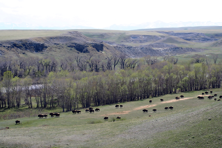
But their preservation on tribal lands is as much spiritual as economic.  Along one of our crossings of the Two Medicine that summer was a tribal herd of 250 Buffalo, part of 20,000 on tribal lands in the U.S. today.

A few months ago, near that crossing, the Blackfeet were among many to sign the Northern Tribes Buffalo Treaty, committing to the preservation and conservation of Buffalo.

A few miles south of my crossings of the Two Medicine, another significant development has escaped the mainstream media.  In December, Congress passed and President Obama signed into law, the Rocky Mountain Front Heritage Act.

It was the result of 37 years of passion and advocacy including a law that was passed in the early 1980s, after the Forest Service began leasing every acre of the Front for oil and gas development, only to be vetoed by President Reagan.

Along a hundred miles of Front I drove that day, the new bipartisan legislation designates 67,000 acres of National Forest as part of the Bob Marshall Wilderness and the Scapegoat Wilderness.   It protects another 208,000 acres in a conservation management area.

The conservation area prevents the expansion of motorized use, prohibits new roads and protects horse, foot and cycling trails as well as what biologists consider among the top 1% of wildlife habitat in America.

An average of nearly 70% of the private land use in the three counties most involved is still used for pasture, rangeland and cropland.  The legislation had the support of many ranchers including Dusty Crary near Choteau.

Tourism and recreation, along this stretch of Rocky Mountain Front, now generates 19% of employment and growing.

In the West overall, areas such as this along federally protected lands are associated with higher rates of job growth, 345% between 1970 and 2010, compared to 83% in non-metro counties with no protected federal lands.

There is definitely a dividend from conservation.

Friday, September 05, 2014

Tweaking Parenting Style to Reduce Poverty

Keeping a promise made at the end of the essay posted yesterday, this follow-up reveals two fleeting encounters with stereotypes of my own, as well as a couple of studies brought to mind by a surprise stop along the way.

No matter who we are or the color of our skin or where we grew up or how tolerant and accepting we have become or think we are, we’re all bigoted in some way.  The trick is to catch ourselves.

For me, one of two fleeting glimpses occurred along U.S. Route 36 as Mugs and I crossed the Wind River Reservation last month on the stretch of slightly rolling hills in Wyoming that finger up between the Middle and Southern Rockies.

By the way, if you’re not into Walt Longmire novels, or the acclaimed TV series, a good non-fiction about the struggles between cultures there over the past hundred years is Geoffrey O’Gara’s lyrical and even-handed account in his book entitled, What You See In Clear Water.

Another of his books is one I’ve re-read on other cross-country trips since I retired from a four decade career in destination marketing.  I first read it in 1989 as I relocated from the Far West to Durham, North Carolina, and the author wrote while he was relocating from the east to Wyoming.

Entitled A Long Road Home: Journeys through America’s Present in search of America’s Past, it intersperses memoir and history with excerpts from the back roads travel guidebooks written during the Great Depression of the 1930s by writers employed by the WPA Federal Writers’ Project called the American Guide Series.

While I was tooling along at the maximum speed permitted on that stretch of the Reservation, a Native American rancher slowly pulled out in front of me without accelerating so while maintaining speed I simply signaled into the other lane to pass.

Suddenly the pickup feinted into my lane to block me and the driver laid on his horn while flipping me the bird.  My mind flashed a stereotype of Native American drivers (as well as farmers in Idaho) commonly held by ranchers where I grew up.

Then I could see in my rear view mirror that the rancher had pulled on the highway for only fifty feet or so to then turn back into his ranch via another road.

By the time Mugs and I settled into Casper for the night I was ready for a tall cool one at a steak place where another encounter reminded me that I, too, am subject to stereotypes.

Surrounding me suddenly in the bar area where I was eating, were members of a motorcycle gang called the Silent Sinners, many of whom were apparently returning from a big bike rally up in Sturgis, South Dakota, in that nook pointing into Montana and Wyoming.

The group is an offshoot of a branch of the Sons of Silence in Colorado and one of eight clubs linked by the Justice Department as conduits for criminal enterprises.  Turf for this group included Wyoming and northern Utah, but the overall reach of the Sons of Silence is across 12 states.

But the members around me that evening were congenial, kidding me about having grilled chicken and veggies in a steak place and for drinking red spirits rather than brown.  Later they acknowledged that they suspected I road motorcycles by the Harley emblem on my trailer hitch.

A friend of mine who lives on the west coast of Florida assumes that any neighborhood with a couple of motorcycle owners must be sketchy, stereotyping the 9% of Americans who do by lumping them with the 5%of riders who belong to outlaw gangs.

That night I caught a glimpse of both my own prejudice and being prejudiced against by others.

Early the next morning, Mugs and I set off across the roller coaster hills and dales of Wyoming rangeland that run along the Southern Rockies as they jut up from Laramie, while imagining hired guns for the cattlemen’s association riding north during the late 1880’s Wyoming Range War to attack immigrant settlers.

Soon we dropped down onto the flatter plains that run north through Denver and up past Cheyenne where we turned east down across the high plains of Nebraska, then across its Great Plains where my ancestors began their trek out to the Rockies in the 1840s.

At Lincoln on the western edge of the corn belt plains, we stopped for the night.  Running through my mind that day as things turned violent in Ferguson were two studies.

Pundits had been excusing the violence centered around the looting of 56 stores as an outgrowth of frustration over poverty but poor people are no more violent than other Americans, and maybe even less.

To the frustration of legitimate protestors, their activity had provided cover for criminals, just as research sociologists have long warned that petty crime and blight does, making poor neighborhoods victims of crime.

As I noted yesterday, nearly 4,000 African-American slaves had toiled in the county around the city of St. Louis, including what became Ferguson, in 1860 just before the Civil War.

I don’t know that any descendants of those slaves live there today.  It was predominately white until 1980.  But a 2010 study by researchers at the Institute for the Study of Labor found that even today in parts of counties such as this, the legacy of slavery is still manifest by economic inequality, especially the gap in education.

But the paper “Being Black Is Not A Risk Factor: A Strengths-Based Look At The State Of The Black Child” points to findings that support the idea that it is “being poor in general that is the real risk factor.”

Nearly half of “black children in families living below the poverty threshold live in areas where at least 30% of the residents have incomes below the poverty threshold.”

The ratio is 1-in-4 in Ferguson, MO, but more like 1-in-2 among African-Americans there and in similar places compared to 35% of blacks, 33% of Hispanics and 13% of whites nationwide. 

A number of white progressives as well as some African-Americans get very upset at references to poverty as cultural, perhaps because many assume that implies it is brought on by race.  But in my reading this is far too narrow a use of the term cultural.

When in his remarkable essay entitled, “Inconvenient Truths About Poverty,” conservative critic and columnist Joe Queenan, who himself grew up in poverty, references poverty as “rooted in interlocking self-fulfilling prophecies, he isn’t writing about race.

The next morning Mugs and I headed south to St. Joseph, Missouri, and then to avoid traffic and road construction in Kansas City and St Louise as well as the corridor between, we took a new route along much more scenic U.S. Route 36 to cross the Mississippi at Hannibal with plans to cut south to Nashville.

We stopped for gas at Chillicothe where in 1855, Reverend David White, a minister in the Christian church was run out of town on threat of lynching for preaching against slavery.  This was also the route Mormons had taken back to Illinois in 1839 when threatened with an extermination order by the governor.

Across the bridge we looked for a “Blue Highway” south to Paducha but turning too soon, the GPS took us back southwest through incredible Illinois countryside, back across the bridge at Louisiana, Mo and down scenic State Route 79.

At I-70 I headed west past St. Charles, taking the I-270 beltline to get around traffic and stopping for gas to get my bearings and find the best way back across the river and back on track.

Two elderly black gentlemen on each side of the pump in front of me were talking in loud voices although they were both agreeing with the rhetorical question, “why were those boys walking down the middle of the street anyway?”

Out of curiosity, I asked “Where is Ferguson anyway?” I was on my way in the store to get water and received a resounding chorus of, “Son, you just crossed over it.”

There is always a lot of finger-pointing in news reports about poverty, much of it inferring that police and teachers aren’t doing enough.  But rarely does the role of parenting get any play.  According to many studies, perhaps like me, none of us feel we are very good at it.

I remember reading a typology of parenting once that across all groups 32% of parents are “authoritative,” the ideal mix of demanding and responsive, 31% are negligent, 22% are permissive and 15% are authoritarian.

Again, it is not about race, but in a book I read about a decade ago entitled Unequal Childhoods: Class, Race, and Family Life, Dr. Annette Lareau reviewed research that studied the differences in parenting styles across races and socio-economics such as middle or working class and poor.

Lareau found that working class parents and those in poverty practiced what she called “natural growth parenting,” with children free to roam around unstructured. They seemed to feel that kids will soon have it tough enough.  They give orders but avoid too much interference.

Middle-class parents practice a style she calls “concerted cultivation” focused on coaching, teaching self-control, negotiation, understanding how to challenge authority and time management.

Both approaches have drawbacks.  As the saying goes, its also takes a village to raise a child.  The late Dr. John Hope Franklin, a friend and incredible African-American scholar, told stories about how neighbors would discipline him on his way home from school.

Franklin’s research was used in court desegregation classes.  He felt that black parents of his generation felt their children needed to excel, but many in the generation after desegregation mistakenly spent too much time trying to cushion life’s bumps.

He wouldn’t be surprised that a new study in Michigan found that minority parents were far less likely today to follow child restraint laws and guidelines when they drive, but might be to know that this was regardless of socio-economic status.

Dr. Lareau found that the different parenting styles of middle class and poor or working class parents may reinforce class-based inequality by reproducing it from one generation to the next.

She argued in her book that this distinction “arbitrates opportunity in America more powerfully than any other demographic characteristic including race.”

A recent study that correlates to self-regulation in childhood found its strongest link to parenting style, especially among low income children and males regardless of minority status, household composition and parental education.

A newly published study by Canadian researchers entitled, “In Praise of Demanding Parenting: The Effects of Parenting Style and Poverty on Obesity” finds parenting style significant regardless of age, sex, parental education, immigration status, family functioning score, birth order or maternal age.

Authoritarian parents risk self-esteem; permissive parenting risks regulator deficits.  Each parenting style has advantages and disadvantages but it is worth considering the role parents, families and neighborhoods can play in overcoming poverty.

Thursday, September 04, 2014

Risk Factor Ruminations on the Road to Casper

By the time the events surrounding the shooting in Ferguson, Missouri began to dominate news reports last month, Mugsy and I had just turned onto a segment on the return leg of our most recent cross-country road trip that was new to us.

As it almost always does during a feeding frenzy when far too many news outlets resort to speculation and grasping at anecdotes and dichotomies such as saint and sinner, those with agendas tend to usurp attention.

Running Durham’s organization responsible for serving the news media at the time, I had a front row seat to this formulaic pattern during the the now infamous claims of a stripper against some Duke Lacrosse players.

The police and the local newspaper had rightly closed the case, but the paper in nearby Raleigh threw gasoline on the embers, inflaming listserv advocates in Durham anew and within a day, a similar national frenzy ensued making it very difficult year to be in the “calm down business.”

Predictably, racism had become the storyline in Ferguson and I wondered as we cut southeast from Dubois, Wyoming along the Wind River Range if any of those producing stereotypical reports that day had ever read the report I did before I left home entitled Being Black Is Not A Risk Factor.

It’s being poor but it is even more complicated than that, which came to me the next day when my thoughts turned to another study on the stretch from Lincoln to Nashville including an unexpected stop.

The report is the kind of analysis of African-Americans by African-Americans that seems to quickly divide those eager to show progress in the struggle to overcome stereotypes from those who won’t let them go for fear of losing leverage to continue the struggle.

I first witnessed this in the early 1990s when an African-American, Dr. Shelby Steele, now a fellow at Stanford’s Hoover Institute, first published a remarkable book entitled The Content of Our Character: A New Vision of Race in America.

It was also made apparent a few years later when a series of essays were published entitled, The House That Race Built, including a favorite of mine by Nobel Prize-winning Toni Morrison.

There is a coarseness in news coverage surrounding race that for me is at the root of why 80% of blacks think Ferguson raises important issues about race while nearly 50% of whites think it got more attention than it deserved.

It isn’t because these whites are all racist, although plenty of both blacks and whites are.  It is due to the fatigue that stereotypical and anecdotally-frenetic news coverage creates reminding me somehow of a verse in Paul Simon’s Me and Julio Down by the School Yard:

In a couple of days they're gonna take me away
But the press let the story leak
When the radical priest come to get me released
We was all on the cover of Newsweek

Apparently the BBC refused to lay it because it mentioned Newsweek by name.

That stretch I was driving that day of US Route 26 crosses the reservation for Eastern Shoshone and Arapaho people along its way to Casper near where two of my great-great grandfathers and a great (x3) stopped to build a ferry across the North Platte River in 1847.

This is Longmire country for fans of the acclaimed A&E series and/or the Craig Johnson novels upon which it is based (although the area around Santa Fe is used as a stand-in.)

When I watch television, it is entirely via streaming now and I find I am drawn to shows and movies where the landscape also serves as a character such as Longmire, The Killing, Wallander, Endeavor, Night Train to Lisbon, etc.

This part of Wyoming is a gently rolling sagebrush steppe of the Great Plains filling a gap between the fingers of the Middle and Southern ranges of the Rockies.

I have always been on the least intolerant end of that spectrum but still within a few hours that afternoon, I was able to catch fleeting glimpses of my own prejudice, one while crossing the reservation and one during dinner that night during a layover in Casper.

Until the end of the 1850s, a decade or so after all but two of my sixteen fifth generation ancestors had made the cross-country trek from various parts of America to settle along the western slopes of the Rockies, news coverage simply reported events.

Oh, there was plenty of vitriol and opinion too, but in July 1859, a new dimension was added when the first-ever news “interview” was conducted by Horace Greeley of Brigham Young during a stop in Salt Lake City by the New York Tribune publisher.

In Manhattan, Kansas, in route from New York to San Francisco, the then 48-year-old Greeley had caught up with Tribune journalist Albert Richardson to take a new, quicker route just opened with partners by the founder of the Pony Express.

As Richardson had earlier passed by what would become Ferguson, Missouri, land had just been donated to the Wabash Railroad coming down from Toledo on the condition that a station be built there.

At the time, nearby St. Louis had a population of around 160,000.  But the surrounding county, including around Ferguson, was still very rural.

While Richardson notes that city streets there were filled with debates between pro and anti-slavery residents, out in the county, including where the Ferguson Train Depot would soon rise, there were still 1,156 slaveholders holding 3,346 African-Americans in slavery.

The Leavenworth and Pikes Peak Express Company ran its stagecoaches along part of the route one of my great-great grandfathers had captained a wagon train five years earlier, but then along a much faster route through just-founded Denver and then up and over the Southern Rockies.

Not only states, but towns within states such as Kansas, were divided as free or pro-slavery at the time and a fascinating read is the book entitled Beyond the Mississippi written by Richardson two decades later from notes in his journal.

Downloadable free including into a Kindle app, Richardson’s narrative, a first-hand snapshot of Missouri, Kansas, Colorado, Utah and California in the pivotal years just before the Civil War, is a great cross country travel companion.

The news interview is rapidly becoming a thing of the past when it comes to news reports.  There are still quotes and sound bites but mostly anchors now interview other reporters who respond to questions by substituting opinion and conjecture as stand ins for others who were directly involved or with direct knowledge.

Tomorrow, more about those fleeting insights into my own stereotypes and the real risk factor.

Wednesday, August 20, 2014

Sensing Place - A Proposal for Digital Mapping

Soon I hope, digital cartographers will add a layer on GPS maps to show ecological regions much as they do terrain now.

Updated research that came out while we were on the road found that 90% of map use now is on a smartphone or tablet with nearly 6-in-10 Americans tapping into GPS on smartphones each month and more than a quarter doing so on a tablet.

We use them even more on vacation where 89% of Americans now take a smartphone along and more than half a tablet.  GPS is used by 77% and local search by 92%, surprisingly with usage by men only slightly less than women (smile.)

Nearly half now use the devices to access visitor guides.  Americans on vacation are now 2.5 times more likely to use GPS over a paper map or printed directions.

Now that my CoPilot GPS app isn’t reliant on cell coverage, I probably won’t order GPS in my next Jeep, although it is cool to look over at any time and see the posted speed limit.

Use of built-in-vehicle GPS is now below 17% and most of those are people my age or older and in the Northeast.  Within three years, smartphones will be used by 84% of Americans while tablets will increase to 71%.

Digital maps today are layers of data using GPS.  When a user runs into inaccurate directions it is most likely because the jurisdiction isn’t updating impedance data or new routes.

Or platforms such as Navtech or Mapquest or Google update at their end only periodically.

One of the roles of destination marketing organizations is to monitor both ends of that process and spur constant updating.

Many people only think of historic buildings when they think of sense-of-place but place based assets also include distinctive culture/history and natural/environment.

I first incorporated ecoregions into my work promoting and differentiating cities in the late 1980s about the time I arrived in Durham, North Carolina to jumpstart visitor-centered economic and cultural development (DMOs often called CVBs.)

At its coarsest level, North America has 15 ecoregions.  Zoom in a level and you see 52.  At level III, the USA has 104.  Zoom into the state level and a state such as North Carolina has 29 different areas of distinct geology, physiography, vegetation, climate, soils, land use, wildlife and hydrology.

Durham, where I still live in retirement, has a very distinct cultural identity and different sense of place than Raleigh, a metro center further south and east with which we co-own an airport, but I didn’t realize that is also true of Fort Worth and Dallas, which are also often lumped together because they co-own an airport.

Fort Worth is in a unique part of an ecoregion called the Cross Timbers, while Dallas is in the Blackland Prairie that stretches down to San Antonio.

Cross Timbers is a “complex mosaic of upland deciduous forest (shorter but post and blackjack oaks with striking habits,) savanna, and prairie” that stretches from north of Austin up past Fort Worth and through central Oklahoma into Kansas.

It is the western most extension of the eastern oak-hickory forests covering nearly 20 million acres at one time and possibly the least disturbed.

When Texas became a state, there was a provision to divide it into five different states but it has an incredible 56 different ecoregions.  It is a much more diverse state than often depicted.

I have a general idea in advance of the routes we will take on each cross-country but Mugs and I don’t zero in on the route we will take each day until we punch it into GPS and take a fresh look at ecoregions along the way.

The day we left Fort Worth for Santa Fe, we were listening to Amarillo By Morning, one of my favorite songs by George Strait, first heard when it was recorded the year my daughter was born by one of its songwriters, Terry Stafford (whose 1964 version of Suspicion is a classic.)

Our route up through Henrietta and Wichita Falls took us up along US 287 through four beautiful ecoregions of Texas.  Amarillo, where we turned west toward the Southern Rockies of northern New Mexico is High Plains, similar to Denver, Fort Collins and Cheyenne.

Overall, we took five unexpected routes during this trip.  More on that later.

Friday, August 15, 2014

Unique Provinces

My just concluded cross-country Jeep trip with Mugs was 300 miles shorter than last year but still close to 7,000 miles round trip.

This was because we parted company with my daughter and two grandsons after a farewell breakfast at a favorite diner in Lima (pronounced like the bean,) Montana.

Within a few miles as we crested the (western) Continental Divide, they continued their descent down across the Snake River Plain and back to Salt Lake City where they live high on the slopes of the Wasatch.

Mugs and I then cut sharply east via country roads along the Idaho slopes of the 30 + mile Centennials, a uniquely west-east trending range of the Bitterroots, where much further north we had spent a week on a lake in the Northern Rockies as we do each year.

This short but dramatic range ends at my native Henry’s Fork River where the southwestern corner of Yellowstone Park noses between the Centennials and the 40-mile north-south trending Teton range.

When I travel, I consult maps of ecosystem provinces and regions as much as I do roadmaps.  You can view them at the national level and/or then drill down to see more distinctions at the state and even county level.

Their respective states treat them as separate, but both the Montana and Idaho sides of the Centennials and the Idaho and Wyoming side of the Tetons share an ecosystem distinct from other parts of their respective states called the “Middle Rockies.”

In the nook of Idaho that points up into those two states, the “Middle Rockies” ecosystem is a narrow crescent, thinnest below Monida and I-15 on the west, deepest from the Continental Divide to Ashton and then thinning out again between Tetonia and Driggs at a point where a break in the foothills provides a spectacular close up view of the three Grand Tetons.

Down below this crescent stretches the broad flat arch of the Snake River Plain, the only impression of Idaho visible from Interstates 84, 86 and 15.

In my opinion, the ecosystem maps are far more relevant than tourism maps which appear to have been arbitrarily manipulated to appease powerful population centers or make them more relevant.

I assume this is why the tourism map of South-central Montana, divides the Middle Rockies by running a narrow 15 mile wide shaft down the west side of Yellowstone giving it to Bozeman while nudging historic Virginia City under Butte.

Similarly, Idaho’s arbitrary tourism partitions give the misimpression that Idaho Falls down on the Snake River Plain is somehow up in the Yellowstone-Teton nook I just described.

Ecosystem maps such as the one at this link of the Greater Yellowstone Ecosystem are far more useful and relevant to travelers because they are organic vs. political.

Tourism maps may even trip up journalists from time to time.

An otherwise excellent High Country News report I read during the trip is entitled “Idaho’s sewer system is the Snake River.”

It cites Ashton as where the Henry’s (or North) Fork joins the South Fork which had run parallel down the Jackson Hole or eastern side of the Tetons.

But Ashton is actually located less than half way down the Henry’s Fork which doesn’t merge with the South Fork until nearly to Rigby, nearly 70 river miles downstream and just north of Idaho Falls.

Minor distinction, I suppose, for anyone unfamiliar with the area and related only tangentially to a story set more than two hundred miles south and west in Magic Valley where apparently a shift from potatoes to dairy herds is creating problems downstream.

Maybe having spent the final two decades of a career in community marketing helping people grasp that Durham and Raleigh are distinct cities and that the two metro areas that just happen to co-own an airport, I may be sensitive to locations and geography.

If anything though, one would think the report would have pointed out that stakeholders along the Henry’s Fork have shaped a “best practice” plan for its management.

The report was written out of Montana and another condition worth exploring is why, and how so many towns there and in northwestern Wyoming seemed to have caught on to sense of place and the importance and value of being congruous.

While those on the Idaho side seem anything but, seemingly poster children for a statement by sense of place and land use expert, Edward T. McMahon:

“We sometimes forget that every building has a site, every site has a neighborhood, and every neighborhood is part of a community.” (And I would add, every community is part of a setting or landscape).

It is as if, to paraphrase Seth Godwin, that these property owners want to spite the spectacular mountains at their backdrop or they conceive a world where there is only two kinds of stuff, theirs and not-theirs.

More on this later, but this may be at the root of all litter.

Thursday, July 24, 2014

Leaving Something of Ourselves Behind

A friend of mine who teaches strategic thinking and consults for organizations from time to time estimates that 2% to 3% seem to come by this skill naturally.

It was probably embedded beginning at age 3 in the way their parents and grandparents schooled them in pre-school foundational skills.

The professor estimates the percentage rises to 10% at college graduation and then levels off.  He finds it curious that so many  that pick it up naturally studied history in college, not business.

I’m not surprised, really.

Interest in history is piqued during those very early years, and when studied,becomes a way to make connections and see patterns in the world.  It’s about looking back to see forward, all foundations of strategic insight.

Maybe a required course in historical analysis should be required in business schools.

Driving  home from giving a lecture in the mountains earlier this week,  a passage penned by Dr. Peter Bieri for a “philosophical thriller (smile)” and published under the name name Pascal Mercier kept running through my mind:

“We leave something of ourselves behind when we leave a place, we stay there, even though we go away.

And there are things in us that we can find again only by going back there (Night Train to Lisbon.)”

When my paternal great-grandparents and grandparents homesteaded the ancestral ranch the shadow of the Tetons, where I was born and lived until the age of accountability, only one had Idaho roots dating to when it became a territory during the Civil War.

At the time, only 20% of Americans lived outside of the state in which they were born.  Today, it is 33%, half of college graduates by the time they are thirty but only 17% of high school dropouts according to the research in the book The New Geography of Jobs by UC-Berkley economist Dr. Enrico Moretti.

The book is an excellent primer on economic development.

When my paternal great-grandparents and grandparents homesteaded ancestral ranch more than a hundred years ago in the shadow of the Tetons where I was born and lived through the age of accountability, it was so the younger generation could afford land of their own

Only one had Idaho roots dating to when Idaho became a territory during the Civil War but all of them had been born in the Rocky Mountains.

Idaho, at the time, had fewer than 2 persons per square mile, “the census classification for frontier.”  At the time, only 20% of Americans lived outside the state where they were born.

Today, it is only 33% including half of college graduates by the time they are thirty but only 17% of high school dropouts according to the research in the book The New Geography of Jobs by UC-Berkley economist Dr. Enrico Moretti.

Homesteading land made available by the federal government back then worked much as a “relocation credit” Moretti proposes for today.

Homesteaders in the first two decades of Idaho statehood anticipated the routes of soon-to-be-laid railroads which those companies, such as the Oregon Short Line, actively promoted through intensive marketing.

Founded by Union Pacific, “short line” stood for the shortest route between Wyoming and Oregon but by 1889 that railroad was laying tracks north to Ashton four miles from our ranch, then by 1908 up 57 miles over the Rea’s Pass across the Continental Divide to the western gateway to Yellowstone Park.

By 1912, a spur had also been laid from Ashton southeast to Victor where connections were made over the Tetons and up the Jackson Hole to the southern entrance to Yellowstone and the much anticipated creation of Grand Teton National Park.

In 1954, my entire elementary school took a field trip along that spur behind a steam engine a few years before the demise of the Yellowstone Special and the Yellowstone Express passenger trains, one from Chicago and one from Los Angeles.

It was the end of an era but the old rail lines are now being leveraged into another kind of economic development.

Abandoned rail lines are now trails throughout Idaho including the two routes out of Ashton, a thirty mile rail-to-trail along the length of the Tetons and the 34 mile Yellowstone Branch Line Trail through the canyons of the Henry’s Fork from Warm River to the Divide.

In 1896, when Butch Cassidy and his Hole in the Wall Gang robbed a bank in Montpelier, Idaho near where my maternal grandparents would live during my early years, my paternal ancestors were still living just across the Bear River Range.

Soon they headed north to homestead against the Tetons when Idaho barely had 160,000 residents, after the National Forests were first established but before Targhee National Forest was created up behind the ranch in 1908.

But in 1906, Congress responded to powerful special interests by gutting some of the national forests and reopening some of the less forested land to homesteading through the Forest Homesteading Act.

Public use back then did not include recreation and although only 1.8 million acres were eventually patented for homesteads, the act effectively pried 12 million acres away for developers.

In all, by WWII, only 19% of public land had actually been leveraged into  homestead ranches and farms.

When the first of six transcontinental railroads began to tunnel through the Bitterroot Mountains of Northern Idaho, there were less than a thousand non-native people living there.  By 1900, there were more than 10,000 living in each of the two counties through which I’ll soon pass.

Many had moved there because of inexpensive public land given to the railroads and then sold to settlers before construction crews even began grading.  By 1900, these land sales reached 105,000 acrese a year.

That’s the year the lumbering industry arrived after depleting stands in the upper Midwest.  Before 1891, the land from near Spokane, across to Montana and north to Lake Pend Oreille belonged to the Coeur d’Alene Indians, about 500,000 acres left of their ancestral lands by treaty.

Responding to special interests, all but 70,000 acres was pried away.  Even given the Forest Homesteading Act, settlers were soon overrun by lumber “robber barons,” some through legal means, but much of it through fraud.

As I drive down from Lookout Pass and across northern Idaho again, three things will be on my mind.

First is that one day, we need to build in time to detour down the St. Joe River Scenic Byway along a series of Forest Service roads, hopefully astride my Harley Cross Bones.  For now, having Mugs along and my grandson’s eagerness to get to the lake take precedent.

Second is how ironic it is that the route of the Milwaukee Road’s old Hiawatha passenger train is now a 15-mile trail in Idaho alone from Lookout Ski Areas to Pearson for trail bikes and hikers, alternative forms of National Forest economic development.

Another rails-to-trails adaptation is rated one of the 25 best in the nation, a 72 mile asphalt Trail of the Coeur d'Alenes greeneway from the Tribe’s reservation at Plummer, along its namesake lake and up to the early 1850s Cataldo Mission before ending in Mullan.

One of the most spectacular views during my hiking days was heading up the St. Jo River north of St. Maries to its headwaters, a must for fans of the book The Big Burn.

One or the Forest Service heroes of the firestorm, 25-year-old Joe Halm, took his crew to safety there.  Little did I know as we hiked that stretch, that a few years earlier, a group of University of Montana students had climbed up the other side.

Well into a second century of controversy over Northern Idaho logging on public lands, they have been advocating for over 40 years for the roadless area to be set aside as a 275,000 acre wilderness area straddling each side of the Bitterroots.

Third, is what will soon be two Tribal Casinos on the plains above Spokane, near the original Longhorn (southern pit-style) Barbeque restaurant, one a leisure and convention resort opened by Idaho’s Kalispel Tribe and nearly through the approval process by the Spokane Tribe, just desserts I suppose.

To paraphrase Pascal Mercier, “There are things in us that we can find again only by going back to the places were we have left parts of ourselves behind.”

Thanks for keeping me company.

Thursday, July 03, 2014

Our Next Southern Route

The original definition of the Far West didn’t include Colorado, Wyoming or Montana.  The latter two are primarily “plains” states as is the nearly half of Colorado where 88% of that state’s population resides, the part that was originally part of Kansas.

Plains differ from prairies but they are both still relatively flat.  At one point they were distinguished as short grass and tall grass prairies.

By the 1840s when eight or nine sets of my ancestors crossed, the short grass area was just known as the plains or high plains.

Despite their “Rocky Mountain high” reputation, all but 12% of Coloradans live in a mix of piedmont and plains.  Let’s just say John Denver was generous to both Colorado and West Virginia, as he was to tourism in general, back as I finished college and began that career.

Now in retirement, that’s part of the reason Mugs, my English Bulldog, and I enjoy annual 7,000 mile cross country road trips.  This will be our seventh in five years, utilizing largely different routes each time.

I’ve written about the far north route we plan to take back home this year.

On the way out we’ll take the southern route, dropping straight south through Chattanooga to Birmingham after we crest the divide between the Great Smoky and Blue Ridge mountains.

If the world was flat, on a clear day at that crest we might be able to see the Rockies.  At Birmingham, we’ll take I-20 across parts of Alabama, Mississippi and Texas that we haven’t seen from the road.

At the western tip of Texas, we’ll shoot north up the Rio Grande Valley into central New Mexico for a peek at the “needles” of the Organ Mountains near Las Cruses to begin visiting several Civil War sites.

In his 2011 book American Nations: A History of the Eleven Rival Regional Cultures, Colin Woodard writes about two distinct waves of Euro-American colonists who first arrived in the Far West between 1847 and 1850.

“One group-the Yankee Mormons…would found a distinct subculture of independent farmers [and ranchers] in Utah and southern Idaho…the other – the gold hungry forty-niners were highly individualistic frontiersmen in the Appalachian mold.”

Some of my Mormon ancestors who were among the first to arrive along the Rockies were outliers.

Four had southern Appalachian roots or came from the south, six were indeed Yankees and six arrived direct from various British Isles.

Three also became “forty-niners” for a time.

People don’t realize that in the decade when 10.000 other Mormons followed them into the Rockies, missionaries had converted three times that many in England, Wales, Scotland and Ireland combined.

When my great-great grandfather Messersmith enlisted on October 3, 1861 in Stockton, California as “Tom Smith” to fight for the Union in the Civil War, his assignment as a cavalry trooper was to protect gold shipments from San Francisco to New York over the old “Overland Trail.”

He was a Missouri boyhood friend of Mark Twain and had partnered with him to mine for silver and gold in the eastern Sierra Mountains around Virginia City.

But his roots were in the southern Appalachians not far from where I live now.  At the time of his enlistment, Civil War skirmishes had already occurred near Las Cruses.

Using Texas volunteers and relying on Confederate sympathizers, the Rebels were trying to extend a corridor to cut off Union supplies and control strategic harbors in Southern California.

From Las Cruses, Mugs and I will shoot across White Sands, turning north at Alamogordo where during my senior year of high school my uncle flew F-4 Phantom fighter jets at Holloman Air Force Base, including a stint at Elmendorf, AFB in Anchorage.

Before I graduated, his 389th FS was deployed to Viet Nam as part of the 366th TFW, soon to nicknamed “The Gunfighters,” when gun pods were adapted to their planes.

He flew three consecutive tours including 300 missions intercepting enemy MiG fighters over North Viet Nam.

Of the 193 USAF F-4s shot down over North Vietman, 33 were to MiGs, 30 to SAM surface to ground missiles and the remainder to withering AA fire.

Even hampered with the severe restrictions imposed by politicians on AF Phantoms, including the 389th, they shot down 107.5 enemy fighters.

Ignominiously, the last of the old Phantoms will be shot down this year where they have served as target practice since 1991 at Hollomon.

My uncle was killed several years later flying for the DEA along the border with Mexico.  It was 40 years ago, and our visit will be a chance to salute his courage and service once again.

From there we head 200 miles via “blue highways” up to the site of a pivotal Civil War battle 18 miles out of Santa Fe at the Glorieta pass (image in this blog) through the Sangre de Cristo Mountains, the southern most Rockies.

Fifteen years before, two of my Mormon Battalion ancestors passed over the Glorieta during the Mexican-American War.  A couple of years later they were mining gold on the American River.

Confederate forces had taken Santa Fe and planned to hold Gloreita Pass to stop gold and silver from reaching the Union while moving north to seize the gold fields in Colorado.

But Union solders from Denver intercepted the Rebs at Gloreita in late March 1862, pushing them back to Albuquerque and putting an end to Confederate hopes of a west coast.

Three years and a month after Glorieta, the Civil War effectively ended with the huge surrender to General Sherman at Bennett Place in Durham, North Carolina where I now live.

Having mustered out of the Union Cavalry on October 4, 1864, my great-great-grandfather settled near Cedar Fort, Utah, and became a Mormon before marrying my great-great-great grandmother “Lida,” a month before the war ended (at her request.)

The Santa Fe Trail had been blazed into a wagon route between Missouri and New Mexico in the late 1820s, a few months after Mexico revolted against Spain.

For centuries it has been a trading trail by foot, horseback and pack mules connecting the North American interior to Mexico. From Missouri, wagons began carrying supplies down the trail in 1824 returning with gold, silver and furs.

Traffic grew from 26 wagons that year to 414 by 1846 on the eve of the Mexican-American War.  It ballooned to 3,033 in 1860 on the eve of the Civil War, carrying more than 82,000 tons and employing 9,084 men and giving it nearly as much strategic value as the more central overland route through the Rockies.

But its namesake, Santa Fe, wasn’t the terminus.

From there, goods were transited on the Old Spanish Trail, cutting across the Rockies of southeastern Colorado, up and across central Utah and down to Los Angeles and back.

Mugs I will follow part this route before cutting north to rendezvous with my grandsons and daughter and heading to a lake in the Northern Rockies.

By 1880, the Atchison, Topeka, and Santa Fe Railroad reached Santa Fe using portions of the old trail and ending it as a wagon road.

Four years later, my great-great grandfather Harper returned to captain a Mormon wagon train west in 1855 from a new trailhead in Atchison carrying more than 300 French, English, Welsh, and Italian converts.

Leaders in Atchison at the time were joining with others in Topeka to charter the railroad.

By 1885, the “Santa Fe” completed a southern transcontinental railway connection through to San Diego, competition for the Union Pacific’s one across the heart of the Rockies in 1869.

Less than a decade later, the Great Northern punched through another transcontinental route from St. Paul to Seattle through Spokane, soon to be a strategic center for four transcontinental railroads.

When I was a boy, electric train sets were prized, and my favorite was the red and gold nosed “Santa Fe,”  but my favorite railroad logo was always the “Mountain Goat” of the Great Northern.

Regardless of whether we take our own southern route out or do it on the return, it should be quite a trip.  Mugs can’t wait.

Monday, June 02, 2014

The Narcissist’s Blind Spot - A Compelling Dividend

While taking a break recently from helping a friend clean out the huge walk-in “crawl space” under her home in the popular Buckwater Creek neighborhood of Durham, North Carolina, I was marveling that the property backs up to the forested slopes protecting the Eno River.

It occurred to me that I was standing just across the river from an even more unique development by the same builder, a Durham native, and a very early “green” builder.  A similar urban version is opening in the Central Park district of downtown Durham.

These developments are called co-housing, and Durham’s Eno Commons was the third completed of what will soon be 13 in North Carolina following two in Asheville.

Each of the homes or condos are actually individually owned by residents.

More than a hundred are now found in nearly 40 of the United States and Canada after the movement started in Denmark in the 1970s.  One completed in Salt Lake City about the same time as Eno Commons here is across the valley from where my daughter and grandsons live on the slope of the Rockies.

But early Mormon settlers including some of our ancestors experimented with variations of this idea in the late 1800s while other ancestors who created settlements further north along the Rockies and south onto the Colorado Plateau always incorporated the commons.

Planning for Durham’s Eno Commons began a few years before the Buckwater Creek development was completed.  It was a reality by the year 2000.  A park-like neighborhood, it has 22 energy efficient and sustainable households connected by a pathway.

Its residents share as commons the surrounding woodlands, an orchard, organic gardens, a playing field and a Commons House, complete with a guest apartment, along with a barn-shaped workshop including shared tools.

This is why they are often called “intentional” neighborhoods vs. those in name only.

There are many other ways that developments are now incorporating the commons.

One which Mugs and I hope to visit after collecting my grandsons on one of our annual cross country trips lies north of Eagle, Idaho where Dry Creek flows down from its headwaters near 7,000 ft. Deer Point, along the Boise Ridge and out under State Route 55.

Before heading up the western edge of Idaho past Cascade Lake on our way to the northern Rockies where we rendezvous with family each year, we will detour four miles up the creek valley to Hidden Springs, Idaho.

This master-planned community was launched in the mid-1990s about the time Buckwater Creek in Durham was completed.  It just reached build out during the last couple of years.

Hidden Springs is an almost 1,800-acre community of about 850 homes in five neighborhoods with a population of a few thousand residents, half of whom had already been Idahoans in this most conservative of states.

The home designs are neo-traditionals with garages accessed via rear alleys.

Along with its own water treatment facility and a mercantile/village green, 55% of this tiny community or more than 1,000 acres is open space.

This includes 44% of the overall development or 800 acres that is permanently preserved as forested and afforested areas including wetlands and other commons managed by a conservation trust.

Included is a native plant demonstration garden, nature trails, a community farm, an environmental education center, an orchard and a historic farmstead dating to the 1860s when Basques similar to those near our ranch in the Tetons.

Home sites adjacent to the protected areas usually sold first and at a premium ranging from 10 to 30 percent over other sites.  Hidden Springs is also formally certified as wildlife habitat by the National Wildlife Federation.

The community is featured as a case study in a book authored in the last few years by Ed McMahon, a friend of mine who is a sense of place expert for the Urban Land Institute.

The book is entitled, Conservation Communities: Creating Value with Nature, Open Space and Agriculture, and should be required reading not only for developers, but especially for those few whiners who have the ear of power-hungry regressives in the North Carolina legislature who seem bent on stripping communities of development requirements.

Most developers in far more conservative states welcome and exceed these requirements as mere guidelines.  McMahon cites a report showing that wooded properties increase home values as much as 20%, and lots with mature trees such as mine or those backing up to forested land have sold more than 50% faster than others.

This is the same reason that most of the people who buy homes along golf courses are not golfers.  They are guaranteed it will stay a natural area even if it’s not included in calculations of open space.

According to McMahon and the National Association of Realtors, “it is trails for walking/hiking and biking, not golf courses, that are the top choice for open-space amenities in a development.”

While only 1 to 2 percent use golf courses and 5 to 6 percent use swimming pools, anywhere from 50 to 60 percent use trail systems and pathways.

Nearly 60% of homebuyers say they would be more likely to purchase a home near green space.

The developers of Hidden Springs now wish they had done even more to protect open space beyond its boundaries according to McMahon whose book is a must read for developers, planners and policy makers.

Another good book is one that just came out this year, a series of 25 essays by Asheville, North Carolina native and law professor F. Kaid Benfield entitled, People Habitat: 25 Ways to Think About Greener, Healthier Cities.

Benfield’s essays are published on Huffington Post and elsewhere.

Most of my essay is probably lost on regressives in North Carolina but hopefully not on the majority of lawmakers on both sides of aisle who aren’t.

Two new studies may shed light on regressives.

One by a Michigan team of business, psychology and psychiatric researchers found that those who place independence above any interdependence such as ecological are 6 times less likely to carry a dopamine-receptor gene known as DRD4. 

From those I know, this I presume includes regressives.

Another deals with narcissist personalities (self-absorbed or “one-way street folks”.) You know, the folks without any boundaries when it comes to the rights of other people.  They are found in much higher proportions in elected officials than in the general population.

Also true of CEOs.

This group even at the normal range of the spectrum is found to be notoriously oblivious to the societal benefits of the environment.  The difference between normal and pathological is that one just doesn’t care about the welfare of others, while the other intends ill will.

According to medical professionals, the diagnostic manual lists nine traits of narcissists including arrogance, sense of self importance, fantasizing about unlimited power, seeing themselves above others, having a sense of entitlement, being exploitative, lacking empathy and being envious of others.

Business researchers at Fairfield and North Texas universities found that normal range narcissists could be manipulated to adopt environmentally-friendly products if it made them look good in public (an informative read is The Wizard of Oz and Other Narcissists.)

Because very few North Carolinians are empowered to vote them out of office, it falls on the rest of the legislature to be very wary, to read bills very carefully and to defend North Carolina from being harmed by their excesses, even when only through obliviousness.

While only adopted by the state 25 years ago, I dearly love North Carolina and hate to see it stripped any further of the things that make it so appealing.  It is hard to see the actions of regressives as anything other than intended harm.

The weakness of representative democracy is when the tyranny of the few who unelected by the majority of North Carolinians appear bent on its desecration or perhaps are just ignorant to the intent of special interests pushing them to do so.

God help us!