Showing posts with label Watersheds. Show all posts

Friday, October 02, 2015

It Never Leaves You

You can’t grow up in the tiny Yellowstone-Teton nook of eastern Idaho that noses up between Montana and Wyoming as I did during my formative years on an ancestral cattle ranch, without being constantly aware that it will happen again.

There are 40 distinct geologic formations there, but dominant is a huge volcanic eruption that took place there 2 million years ago.

That was the largest in a chain-reaction of eruptions that began 17 million years ago in the southwest nook of Idaho near its borders with Oregon and Nevada.

Sweeping to the northeast, the eruptions worked their way up what became the 400 mile Snake River Plain, which widens from 30 miles to 125 miles as it reaches my native nook where in the shadow of the Rockies that stupendous eruption created an alpine bench above the plain.

A much smaller eruption in that chain created the Yellowstone Plateau just 600,000 years ago and a crater, or caldera, as large as Los Angeles.

Five miles below its surface is a volcano of molten rock the size of Mount Everest, one of 10 Super Volcanoes in the World.

It will blow again someday and the consequences will be felt globally.

But a far greater imprint on my youth was a river formed from springs that filter through the Yellowstone Plateau where it leans on my native nook of Idaho, called the Henry’s Fork.

It surfaces at the Rocky Mountain Continental Divide just 10 miles from the headwaters of the Missouri River on the other side: the waters of the former destined for the Pacific and the waters of the latter to the Atlantic.

It is impossible to describe how beautiful this area is, especially the first 70 miles of the river’s 127 mile length, so I’ll just link to this video. This is the part my parents crisscrossed when they first brought me home from the hospital.

We crossed it to provision in Ashton, to and from school and church, to watch my dad play softball in the evening down near Chester and for Sunday family dinners along with my with my aunts, uncles and cousins down at my grandparent’s house in Saint Anthony.

The Henry’s Fork is where I learned to wade and explore, catch frogs and fly fish, as well as experience the transformative, spiritual influence of nature.

I rarely return, maybe every 20 years or so, but the Henry’s Fork never leaves you.

It is really more like five different rivers in that first half of the river from where a huge spring turns to a river within a hundred feet, through forests, winding across the pastures and native grasses of a caldera, down through steep canyons creating three huge water falls.

Along that stretch it collects creeks such as Buffalo, Elk and Robinson and rivers such as Warm River and Fall River which cascading out of the southwest corner of Yellowstone known as Bechler Meadows.

Herds of Elk “summer” in the meadows there and further up the Henry’s Fork, migrate just above and below the ranch my great-grandparents settled to “winter” at wildlife refuges at Camas and along Sand Creek.

Just beyond Saint Anthony, the Henry’s Fork breaks into channels becoming more like a large, inland delta as it collects the Teton River west of Rexburg and before joining the South Fork as it flows down out of Palisades to form the Snake River north of Idaho Falls.

The portion of the river so important to my formative years is between its headwaters and the Vernon bridge north of Chester.

Most of that time was spent exploring a half mile of riffles and runs located in the tail waters between the Ora bridge and the Ashton Dam.

We crossed the Ora bridge almost daily for one reason or another.  It is near there that my parents first met when my dad stopped to pull my mom’s family out of the gravel roadside’s roadside borrow pit.

When it was erected in 1911, the reservoir created by the Ashton Dam and the Ora bridge installed below it shortened the route to town for my rancher paternal great-grandparents and grandparents.

In the 1940s, its owner the Utah Power & Light Company brought my maternal grandfather and his family there for a few years to operate the dam.

The Henry’s Fork earned a reputation in the west for fly-fishing among enthusiasts in the 1930s but in 1975 I just may have had a hand in gaining it worldwide renown.

Before, during and after the Expo ‘74, a World’s Fair for the Environment in Spokane, I worked to help start a community destination marketing organization to leverage and build on the success of the event.

Part of our job was to interest outdoor writers in story ideas and pre and post trips related to the event as well as laying the groundwork for hosting the Outdoor Writers of America national convention.

Spokane, Washington hosted the six month affair, in part because of its proximity within a day’s drive from so many the Pacific Northwest’s great rivers, lakes, national forests and parks, including the Henry’s Fork.

Who knows? The effort may have even planted or germinated the seed for an article written in Sports Afield magazine in 1975.

The article appeared during my first year as the DMO’s chief exec entitled, The Best Dry Fly River in America—The Henry's Fork, written by Ernie Schwiebert.

Schwiebert, who passed away in 2005, was already a legend and respected author and illustrator.

As an architect, he took advantage of his business travels to scout fly fishing streams.  He had also influenced the founding and growth of a conservation group called Trout Unlimited.

Now 150,000 members strong with 400 chapters including one named for Ernie, this past year alone Trout Unlimited protected 1,400 stream miles and 7.8 million acres of land while reconnecting over 570 miles of spawning and rearing habitat and restoring over 140 miles of river.

But within a few years of Ernie’s 1975 accolade, worry spread among residents along the Henry’s Fork about its sustainability and by 1983 they coalesced in the formation of the Henry’s Fork Foundation.

Watershed organizations such as this were extremely rare back then and unheard of in eastern Idaho.

A relatively short river, the Henry’s Fork watershed still generates an incredible 2.8 million acre-feet of water supply each year including shallow groundwater.

For us lay folks, an acre-foot of water is 325,900 gallons.  About 59% of that flows downstream into the Snake along with 29% in the form of groundwater outflow.

The remainder is consumed for irrigation, expanded for domestic, commercial and industrial use or lost through evaporation.

One of the major economic drivers of this nook of Idaho is tourism and recreation including fishing, which relies on consistent seasonal flows along the river.

So the rub, even where there isn’t a drought, is to calibrate use of the river over the course of the year so that it is healthy, bio-diverse and economically viable for all uses.

At issue is irrigation, not because of overall consumption for that purpose, which has been stable since the 1970s, but because of the way it has changed technologically.

Rather than relying on snowmelt, it now relies primarily on groundwater recharge and discharge.  Officials everywhere often make the mistake of thinking of surface water and groundwater as different but it is all related.

Actually, rivers are crucial to groundwater and groundwater outflow is crucial to rivers.  They are inter-related.

Along the Henry’s Fork, about 24% of the groundwater is recharged by rain and snow.  Another 9% comes from stream seepage and 38% from seepage from canals.

Another 29% seeps back into groundwater when the irrigation is applied.  But irrigation technology has challenged areas along the river, resulting in too much in low areas and not enough in others.

Idaho, as well as North Carolina where I live, are very conservative states.  But unlike a regressive wing of conservatives in North Carolina,  lawmakers in Idaho, part of the more arid west, seem to know better than to tamper with water quality provisions.

Idaho also better understands, out of necessity, the importance of collaboration.

This includes close collaboration between federal and state agencies as well as collaboration between non-government organizations such as the HF Foundation, water users, landowners, businesses and other stakeholders working together as the Henry’s Fork Watershed Council.

Over the last few years, state and federal agencies have re-worked a management plan for the Henry’s Fork watershed.  They have distilled of more than 50 options in the areas of surface storage, groundwater recharge and water conservation, down to 12.

None of the options involve rolling back water quality standards as we apparently just did in North Carolina to please special interests.

The final product is a tactical plan for achieving strategic objectives in the future.  It is well worth reading and emulating.

There is a bright future for the Henry’s Fork River.  The river continued over the last four decades to rack up accolades for fly fishing.

But as noted in a recent overview by Trout Unlimited, fishing there is “indeed not what it used to be.  It is better.”

Tuesday, July 07, 2015

The Significance of our Ephemeral Little Brook

On each morning’s walk before hiking up the slopes of what we affectionately call Mt. Rockwood in Durham, North Carolina where we live, we cross repeatedly over a small unnamed brook.

It is smaller than a stream and way smaller than a creek, or as we said growing up in Idaho, “crick.”  Seasonal or storm-fed waterways such as this make up 60% of the stream miles in America.

There are no fish that I’ve seen but it is certainly home to choruses of bullfrogs.  Similar to 53% of the stream miles in the United States, it is classified as “small, intermittent or headwater,” and like almost 60% of the stream miles in America, it is seasonal and/or depends on groundwater seeps and storms.

They are the subject of efforts in Congress right now, where, at the behest of special interests I suppose such as mining companies, frackers and maybe even developers, who want to exempt these most seminal of waterways from the Clean Water Act.

They have also enlisted more than two dozen states controlled by legislatures holding the same ideology. Here is a link to the definitions to which they object.

The one over which we zigzag each morning comes off a nearby hillside and after flowing through Rockwood Park, it feeds into Third Fork Creek, near its genesis, one of 14 watersheds in Durham.

Much of this fragile brook was protected when a developer named Willie Carver deeded the parkland to the City of Durham in the 1940s; apparently even before this area a little more than a mile from Downtown had been incorporated.

It was a time when developers innately grasped the importance of green infrastructure.  Maybe it should be named “Willie Brook.”

After joining with several other creeks, it now helps fill the 14,000-acre Jordan Lake, a drinking water reservoir south of Durham that outlets as the Cape Fear River where waters from the little brook flow another 200 miles and then into the Atlantic Ocean.

In the March issue of Scientific American, two UCLA scientists give the example that “If Earth was a fully loaded Boeing 777, then its ocean would have the mass of a single passenger.  As strange as it may seem, proportionally our planet is some 100 times drier than old bone.”

And it all starts with these small, intermittent, often epemeral trickles that originate from springs or seeps of groundwater and then combine with storm run-off to create tiny brooks that build into streams and then creeks and rivers.

Even though it is impossible for the Clean Water Act to achieve its purpose without dealing with these intermittent waterways, some in Congress today are seeking to exclude them rather than permit regulations adjusted to address a technicality.

They apparently aren’t listening to 77% of Americans including 58% of Republicans who want even stricter environmental protections.

Nor are they listening to the 155,000 members of Trout Unlimited or for that matter to the $114 billion that 33.1 million anglers such as this generate to the economy.

Many people assume sportsmen and sportswomen such as these are conservative in ideology and half are.  But overall they are all conservationists by nature.

According to surveys, nearly 40% of those who fish and/or hunt believe we have a moral obligation to confront climate change.

When the NRA speaks out against gun control, it represents only 1-in-4 hunters and even then three-out-of-four NRA households overwhelmingly support various controls such as background checks on private gun sales.

Nearly a third support bans on high-capacity clips and assault-style weapons.

Watersheds are often called basins from which various waterways collect.

Durham is divided into two major watershed that fall from each side of the ridge that runs through Downtown, along the railroad tracks.  But each of these break down into several others.

To the north they break down into six or seven watersheds, two that are intercepted to fill two Durham drinking water reservoirs. The remainder, fill Falls Lake, created here so it could be tapped for drinking water down in Raleigh, to make that city viable.

The two rivers tapped for Durham drinking water, the Flat and Little, originate from small headwaters in adjacent southern Person County and north-central Orange County respectively.

In fact, the north and south forks combine to form the Flat River just a stone’s throw from where Willie Carver was born and just before the river becomes a class I-III whitewater river in Durham after storms.

Another, the Eno originates in a 10-acre farm pond in northwest Durham, which after collecting Little River and joining with Flat River and filling Falls Lake spill down to form the 248-mile Neuse River before it flows into Pamlico Sound.

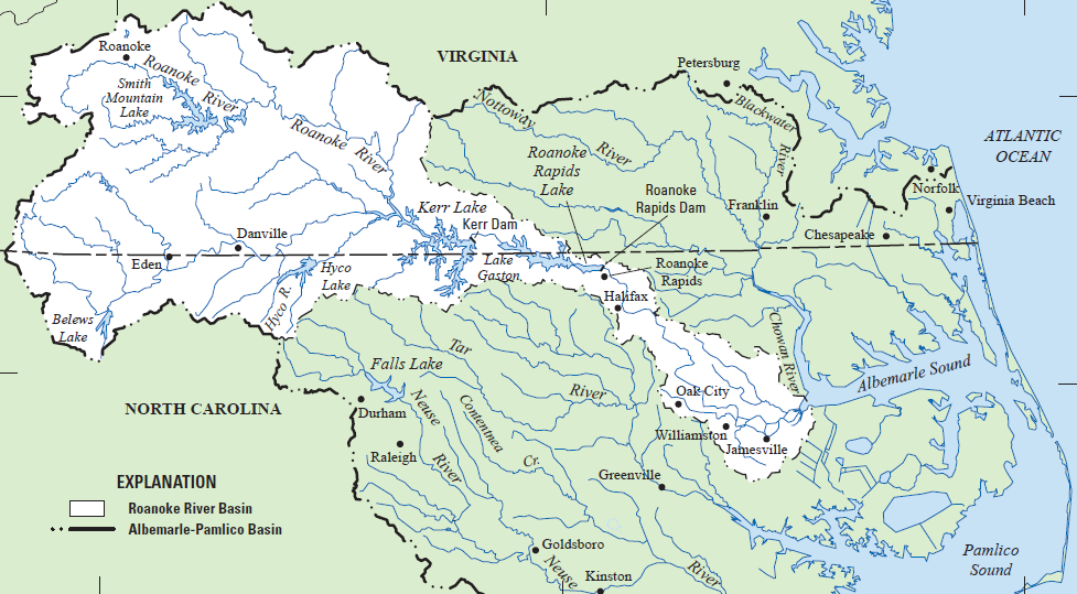
Hyco and Mayo lakes up along the border with Virginia north of Durham are part of the Roanoke River watershed.  That river originates in brooks high in the Blue Ridge Mountains of Virginia and flows down into North Carolina’s Albemarle Sound.

Headwaters are particularly vulnerable to land use changes which is why I’m guessing that special interests, and not just ideology, are behind the push to exempt them from the Clean Water Act.

Rivers are a continuum, a reference coined in a 1980 study that determined, “A river is more than a sum of its parts and that to understand what is happening at any point along the way, you must understand what is happening upstream and what is entering the watershed.”

In North Carolina, 66% of overall stream miles are in headwater streams and 38% are intermittent but because some major rivers and watersheds here are headwatered in Virginia, it is important to understand that state’s make up too.

In Virginia 62% of stream miles are headwater streams.  In the specific area where the Roanoke River begins its journey to Albemarle Sound in North Carolina, 58% of the streams are intermittent while 63% are headwaters.

Angler enthusiasts including many of the 1.5 million in North Carolina along with another 329,000 who visit have spent tens of millions of their own dollars to restore and protect these intermittent streams including 700,000 volunteer hours each year by Trout Unlimited members alone.

In many ways trout are the sentinels of clear water.  It is in these intermittent headwater brooks, streams and creeks that you find native trout such as the Yellowstone Cutthroat I marveled at as a boy growing up near the Henry’s Fork in Idaho’s the Yellowstone-Teton nook.

In North Carolina, it is the Brook trout that is native.

There are still 25 native trout species unique to regions of the country out of the 28 that once existed.  But according to the just-published State of the Trout report, thirteen occupy less than 25% of their historic habitat.

As noted by Chris Wood who is President and CEO of Trout Unlimited, “If you care about clean drinkable water, you should care about trout because they persist in only the highest quality water.”

They are also the “proverbial canary-in-the-coal mine for the effects of a changing climate.”

Tuesday, August 06, 2013

Watershed Roots

I’m within a click of having lived in my adopted home of Durham, North Carolina for 25 years.  But my first 40 years were spent on the western slopes of the Rocky Mountains (my decade in Alaska was in the shadows of what is known as the Rocky Mountain System.)

When Mugs (my English Bulldog) and I headed west recently on what would be a 7,000-mile cross-country trip we crested the eastern Continental Divide in my adopted state at approximately 3,600 feet.

From there we immediately dropped down into the watershed of the Mississippi River which doesn’t end on that southerly route until half way across New Mexico near the end of the the Rocky Mountains, also known as the western Continental Divide.

The Mississippi River drains 41% of the entire United States.  When we crossed the river into Arkansas at an elevation of only 210 feet, we were half way across a flood plain that begins 161 miles upstream at Cairo, Illinois where the Ohio River more though doubles the volume of the Mississippi.

The floodplain covers corners of Missouri and Tennessee, more than half of Mississippi and Arkansas, as well as nearly all of Louisiana.  Failing to “let flood plains be flood plains” has enriched a few at an incredible expense of millions.

From that low point, we climbed back up through the massive river’s watershed to Albuquerque at nearly 5,000 feet, (yes, there are many “mile-high cities”) one of several plains cities that form a 3,000-mile eastern front along the Rockies including Great Falls, Casper and Denver.

Several things were on my mind as we resumed our voyage and drove just before dawn out of Albuquerque and up onto the Colorado Plateau.

The light was a mix of of deep early dawn blues and purples as we listened to the lyrics to two of my favorite songs  beginning with one by Jimmy Webb and the line “by the time I make Albuquerque she’ll be working.”

By the time the sky flooded with sun across the border near Winslow, we were into another favorite co-written by Jackson Browne and Glenn Frey, which became the first single by The Eagles.  We stopped on a corner, but disappointedly for Mugs, there was no “girl, my lord, in a flatbed ford.”  Fortunately, I already have “a lover who won’t blow my cover.”

A few miles earlier I had paid respects to one of my 3rd great grandfathers, Charles Shumway, who was himself the 3rd great grandson of a French Huguenot known as “Peter the Soldier.”

The elder fought in December 1675 on behalf of the United Colonies in the Narragansett War in Rhode Island, after immigrating to the Massachusetts Bay Colony earlier in the 1600s.

I paid respects as well on the banks of the Missouri River during the return segment of this trip to my 3rd great grandmother Julia Ann Hooker.  She died there of diphtheria in 1846 during the year long delay before the trip west.  Charles and my 2nd great grandfather, a teenager at the time, continued on the vanguard wagon train west.

Before settling this northeast corner of Arizona in the 1870s, Charles had created settlements in Kill Buck, Illinois and blazed the Mormon Trail before settling the Salt Lake Valley.  He then created settlements in the San Pete and Cache valleys as well as Kanab, below what is now Bryce and Zion national parks.

At the latter he met Major John Wesley Powell during his first expedition down the Colorado River through the length of the plateau.

While visiting the pueblos nearby of the Hopi Native Americans, Powell also encountered another of my 2nd great grandfathers, Marion J. Shelton, who was finishing most of a decade among the Hopi as a missionary in a failed attempt to help them adapt an alphabet.

Both were introduced to Powell by the “buckskin apostle,” Jacob Hamblin.

Shumway and Shelton are among several of my ancestors who learned Native American languages and served to bridge differences among various tribes and settlers, most often triggered by those who came not to make a home but to seek a fortune in gold or silver.

My native northern Rockies in the Idaho shadows of the Tetons are technically divided from the southern Rockies three hundred miles southeast where my ancestors had crossed over the western divide at South Pass after skirting the Wind River Range south of Lander,Wyoming.

However, on my cross-country expeditions, it feels like the two portions of Rockies are divided two hours southeast of Bear Lake, where the eastern end of the uniquely east-west running 11,000-13,500’ range of Uinta Mountains plow through the Colorado Plateau, forcing a horseshoe bend in the Green River before losing steam in sight of the slightly higher Mt. Meeker, Colorado along the western slopes of the main spine of Rockies.

This also marks the beginning of what showed only as a blank space on maps read by Powell, three to five hundred miles long and one to two hundred miles broad, until the Union Army veteran, who lost his arm at the Battle of Shilo, made expeditions between 1868 and 1874.

John Wesley Powell had been a professor at Illinois State University in Normal where my friend Larry Long now heads up the school of communications.  Powell’s grit and determination was shown when he returned to combat after his amputation to play a role under Union General Sherman at the Battle of Atlanta.

A brevet Lt. Colonel at the end of the war, he preferred “Major” and soon set off to navigate the Green and Colorado rivers as they dissected the 133,000-square-mile Colorado Plateau’s place on the map just as the transcontinental railroad was completed and two decades after my ancestors began settling along the western Rockies.

Actually more than half of the state for which it named is made up more by desert-like plateaus and plains than the mountains for which it is known.  But the Colorado Plateau may cover even greater portions of Utah, Arizona and New Mexico.

The Colorado Plateau is a series of mountain ranges, 11,000 to 13,000 high in places with flat, tabletops.  The Plateau is still rising, while its vaunted canyons such as the “Grand” are actually sinking deeper and deeper and not just due to rivers.

The Plateau begins near Bear Lake in the southeastern corner of Idaho and juts down as Dr. Wallace Stegner once described like a great peninsula between the Great Basin and the Rockies to roughly where the Santa Fe Railroad was laid through New Mexico and Arizona, not reaching Albuquerque until 1880.

The Plateau’s vertical features, including canyons, buttes and arches, are famously the backdrop for Hollywood Westerns.

Most Americans know it for the famous three hundred mile canyon through its southwestern edge, the Grand Canyon in Arizona.  I suspect some of the Plateau’s best views can be seen along the nearly 100-mile Highline trail along the crest of the Uintas with spectacular views from each side.

My backpacking days are long gone but I read an incredible description by Bruce Kirby the month before last in the New York Times.  He hiked the Highline recently with his 4-year-old son aided by horned pack goats. (Goat Tip – they do not like to get their feet wet or stand in the rain – just like Mugs.)

Powell’s small band of explorers cut a few miles north on their way to the Mormon settlement and supply depot of Callville where at that time the Colorado spilled out into the desert.  About 15 miles upstream from what is now Hoover Dam, today Callville (aka Call’s Landing) is submerged beneath Lake Mead.

Freight steamers had begun navigating north from the Seat of Cortez along the lower Colorado River in 1852.  A military vessel had proven it feasible during high water as far as Black Canyon about four miles north of where Hoover Dam is today, almost making Call’s Landing a port.

What Father De Smet means to the exploration of the northern Rockies,  Father Silvestre Velez de Escalante means to the Colorado Plateau.  At 26 years old, Father Escalante ventured north from Sante Fe in 1776, the first year of the American Revolution and weeks before the signing of the Declaration of Independence.

A huge Catholic cross in his memory rests high above the Mormon town of Spanish Fork, Utah.  Father Escalante, a Franciscan, was seeking better supply routes between missions in California.  He crisscrossed the Plateau as Jedediah Smith and others would, but it still left a blank spot for Major Powell to fill in on maps a hundred years later.

Powell is responsible for development of the Intermountain West.  He understood the importance of watersheds there and once recommended to Congress that state borders there be formed around watersheds.

They should have listened.