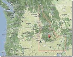
It happened again. Last week during a luncheon, after learning I was born in Idaho, a very nice lady seated near me responded “so what did you think of those caucuses.”
For some reason, like that famous 1976 cover of The New Yorker magazine, many people, especially in the Southeast including my adopted home state of North Carolina, seem to think only as far west as Iowa when they hear the place name of Idaho.
Granted, along with Indiana and Illinois, they are both “I” states and all four are known for growing vegetables that are starches. But Idaho is about much more than famous potatoes.
As a boy, whenever we traveled across the state to visit adjacent Washington, one of six states that border Idaho along with a foreign country, I was always mystified that Washington State’s nickname, self-proclaimed by a realtor is “The Evergreen State.” After traveling across Idaho through several mountain ranges and carpets of forest it always appeared to me that the majority of Washington state was actually barren Columbia Plateau which does in fact cover nearly 40%.
Sixty-percent of Idaho is covered by national forests alone. But just as the City Council in nearby Raleigh did when it emerged from a recent meeting to humorously self-proclaim it the city of innovation in hopes it might become one and catch up with Durham, an enthusiast in Idaho leapfrogged its dominance for timber, cattle, horses and gemstones in the early part of the last century to proclaim it famous for potatoes in hopes the then fledgling crop would catch on 1,700 miles east in the Chicago restaurants of another I-state.
Today, savvy marketers understand that genuine and overarching place brands must reflect traits that a community or state truly owns in the minds of both external and internal audiences rather than just the momentary aspirations of boosters. It is critical that places be able to deliver on the personalities they convey.
That same basaltic Columbia Plateau spills out of Washington and carves to the south of Idaho's 80 recognized mountain ranges, straddling the mighty Snake River through the small portion now famous for potatoes as it curls up through Eastern Idaho stopping short of my birthplace along the North Fork of the river in the northeast tip of that nook bordering Montana and Wyoming where the Targhee National Forest scales the 10,000 foot Centennial and the 14,000 foot Teton ranges bordering Yellowstone National Park.
With its extended northern panhandle, Idaho is deceptively large, eclipsing all of the New England states combined. If all of the lower 48 states were ironed out flat, Idaho is so mountainous that it would be the largest. It also has waterfalls higher than Niagara, canyons deeper than the Grand Canyon, 2000 natural lakes, 16,000 miles of rivers and streams (nine of which are designated wild and scenic) and 50 mountain peaks over 10,000 feet.
While not ethnically diverse by any standard, Idaho has the largest community of Basques outside of Spain and France and it is the aboriginal home of nine tribes of native American Indians, four of which still have a major federally-recognized presence today.
Idaho is also much more sparsely populated than most states with just 19 persons per square mile compared to 87 nationwide and 196 in North Carolina.
But even had she been thinking 1100 miles further west than Iowa, my seat mate at the luncheon would still have been partly correct. This year the Idaho Republican Party will switch from a primary to caucuses to elect delegates.
So while Iowa and Idaho are quite different geographically, they are not all that different politically.
No comments:
Post a Comment