Nearly 30 years ago, I drove my venerable Porsche 911s Targa out across the Great Basin following a brief visit with my then 14-year-old daughter.
It was along a remarkable stretch of U.S. Route 50, a “blue highway” nicknamed “The Loneliest Highway in America,” a label proudly embraced after first used as a pejorative.
Of course, as they do on paper maps, secondary highways no longer show up as “blue” on digital GPS maps but as more of a goldenrod. Just doesn’t have the same ring (smile.)
This is a fragment of the 1913 Lincoln Highway, the first automobile route across America, roughly following the old Pony Express/Overland Stagecoach route.
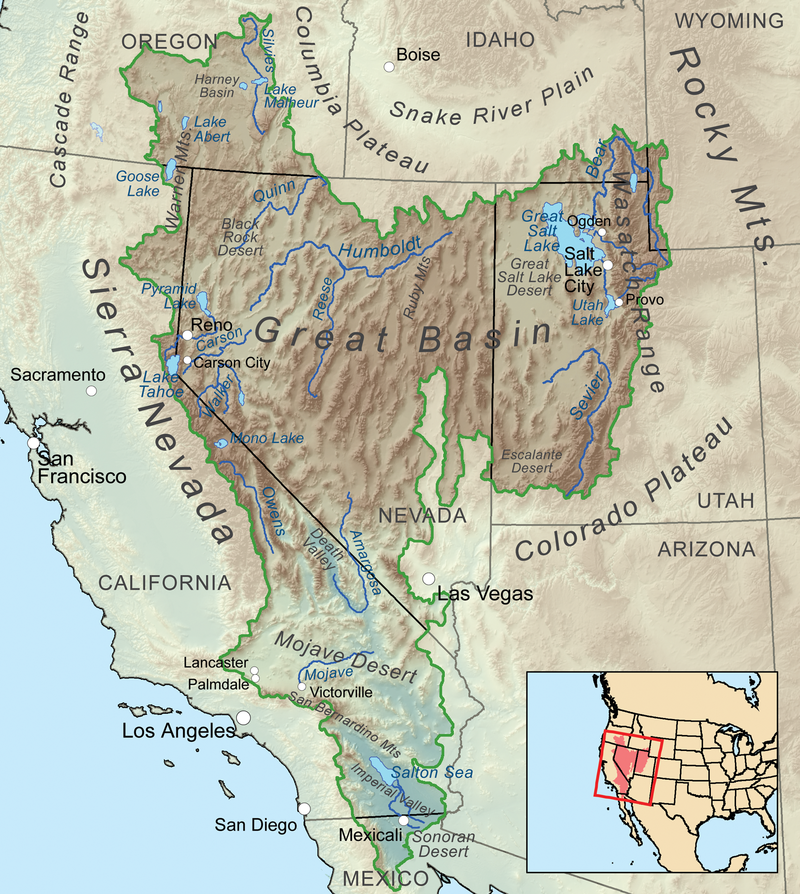
At its coarsest level, the Great Basin is a mild desert that covers western Utah and a tiny corner of Idaho, nearly all of Nevada skirting Las Vegas (Mojave Desert) into east-central California and up into eastern Oregon between the Cascades and Rockies.
The northern Nevada portion, where dissected by Route 50, is more specifically called Basin and Range because it includes a spectacular mix of steep mountain ranges, flat to rolling arid valleys and rangeland, and even alpine forests.
But the Great Basin got its name because rivers there materialize and then dead-end into lakes with no outlet or they disappear into “sinks” (dry lakes), e.g. the Great Salt Lake or the Humboldt Sink where that significant 330-mile river just disappears.
This was foreign to European explorers who understood only divides between watersheds where rivers ultimately opened into seas and oceans.
Part of my most recent cross country trip traced part of the route of an expedition led by two Franciscan priests in 1776.
It set out just as Americans along the east coast declared Independence, to find a trade route from Santa Fe to Monterrey.
They made it north as far as Utah Lake near the location of Brigham Young University but the maps drawn by expedition members reflected a misunderstanding of descriptions from Ute Indian guides.
Illustrations included massive rivers whose mouths had been earlier discovered along the Pacific Coast in what are now northern California and Oregon flowing from as far away as the Great Lakes.
Versions of these maps were in use right up until 1846 when further exploration by Captain John C. Frémont and Kit Carson learned of the existence of the Great Basin.
Accounts reached my Mormon ancestors weeks before my great (x3) grandfather Charles Shumway and his family led the way across the Mississippi in 1846 on what would be a 1,500 mile exodus to a new home in the Rockies above the Great Basin.
At the time of the Lincoln Highway’s conception in 1912, less than 9% of the roadways anywhere in America had improved surfaces such as gravel.
Many states at the time constitutionally prohibited such “internal improvements” forcing cities, towns and counties to go it alone.
Even by the 1920s, when the Federal government incentivized the states to build roads, Utah, still smarting from when a portion was lopped off in 1861 to create Nevada, refused to pave its stretch of the “Lincoln.”
To no avail, Nevada pled and even offered to pay for a portion so for a time the Lincoln Highway bypassed Utah cities.
My primary mission during that Route 50 hiatus from my career was solitude and time for reflection and forgiveness, but a secondary pursuit was to trace a portion of the lives of three ancestors.
My first stop was Fort Ruby, near the terminus of a stagecoach line that two of my great-grandparents, George and Eleanor White, operated for a time in the 1890s.
After their teamster years, my great-grandfather would landscape the upper campus of Brigham Young University which I would attend several decades later.
Fort Ruby would have looked as it does at this link, when one of my great-great grandfathers Tom Messersmith, served in the Union Cavalry there months after the fort was first established in 1862.
A fellow Missourian later joined by his friend Samuel Clemens (Mark Twain) as partner on a claim along the Comstock Lode.
But as news about the attack on Fort Sumter and secession by 11 Southern States arrived west, in October 1861, my great-great grandfather had crossed through the Sierra’s to enlist in the Union Cavalry in Stockton simply as “Tom Smith.”
When he had left his home county, an area from Jefferson City down to the Arkansas border. there were 169 slaveholders holding 987 African-Americans in slavery but few in his township.
Most of the state’s 115,000 slaves were concentrated along the Mississippi and Missouri rivers.
But Thomas Messersmith was a fourth generation German-American descended from Palatine Protestants who had fought for American freedom with the Virginia Militia as early as 1774.
German-Americans were among the small minority in Missouri who were outspoken opponents of slavery including small yeoman farmer/ranchers in the pastures and hills along the Osage River as it slices through the Ozark Highlands.
When he relinquished his claim with Twain to enlist, that area was governed by both California and Nevada, a boundary later settled by arbitration.
In the years before the Civil War, California, while voting to be a free state was staunchly Democratic. Sympathetic to the South, Southern California had wanted to secede and join the Confederacy.
But Abraham Lincoln carried California in the Presidential election by six-tenths of a percent when the Northern and Southern Democratic candidates split the vote slightly in favor of the North.
Things were anything but settled as Tom enlisted with the Union. A coup by Southern sympathizers to seize ports and with counterparts in Oregon to form a new “Pacific Republic” had been narrowly foiled.
Militias around the state were embattled both internally and with other militias to hold the Union together as federal troops were redeployed to the east.
A Confederate flag had even been captured flying in Sacramento two month earlier.
But as my great-great grandfather rode down out of the Sierras, Leland Stanford, a Republican was overwhelmingly elected governor over a Southern Democrat.
After enlistment in Company A of the 3rd Regiment of California Volunteers, Trooper Messersmith traveled to the Benicia Arsenal on San Francisco Bay for outfitting, then briefly deployed up to Fort Baker east of Hydesville and about 24 miles south of Eureka.
The assignment where hostilities with Chilula, Lassik,Hupa, Mattole, Nongatl, Sinkyone, Tsnungwe, Wailaki, Whilkut and Wiyot Native American peoples broke out in what is known as the Bald Hills War over disruption caused during a gold rush there.
While here, one of Twain’s letters asks his brother to forward some Spanish spurs he had left hanging in his office to my great-grandfather.
From there Company A was to join the rest of the regiment at Fort Douglas along the Wasatch Mountains above Salt Lake City but they were waylaid at Fort Ruby, Nevada where Shoshone Indian attacks and fear of Confederate militants threatened gold shipments along the Overland Stagecoach Route, which were desperately needed to fund the Union war effort.
Then they were backtracked to Fort Churchill, Nevada to put down threats from Paiutes, finally arriving at Fort Douglas in January 1864 just as the 13th Amendment to the Constitution is proposed, ending slavery.
Fortunately, his unit did not reach Fort Douglas in Salt Lake until January 1864.
There he would have heard the details of a tragic battle (renamed massacre) on the Bear River less than 12 months earlier.
It took place ten miles north of the ranch owned by two other great-great grandparents who had helped establish the first permanent settlement in what is now Idaho and learned enough Shoshone language to interpret.
Having battled related Shoshone Indians for several months through Nevada, it isn’t clear where Tom Messersmith’s sympathies may have been as he heard about the slaughter.
Nearly 500 Northwest Shoshone men, women and children were trapped and killed by 300 troopers who lost fewer than 20 casualties.
Only after the war was it clear this was largest massacre of Native Americans in a single day ever by the U.S. Army.
But how my great-great grandfather lived the rest of his life and what he taught my great-grandfather tells me it may have bothered him much more than other troopers.
When his enlistment ended in October 1864, he had just turned 30. He backtracked into the Great Basin along the old Pony Express route to Cedar Fort near Camp Floyd which had been dismantled when troops were called back east at the beginning of the war.
There he settled and was “persuaded” to become a Mormon. Five months later he married my great-great grandmother “Lida” who had made the trek to Utah as a five year old.
Together they ranched sheep among the Skull Valley Indians, a Goshute band of the Western Shoshone native to the Great Basin, a band my great-grandfather would regularly take me to visit whenever we visited to take them food, something we did more frequently as I attended college along the the mountains across Utah Lake.
I wasn’t much older than my great-great grandfather had been when he settled down as I retraced that ancestral stretch along U.S. Route 50.
The landscape was foreign to anywhere I have lived and yet somehow familiar.
It may be the loneliest stretch in America but I found it ideal for reflection and rejuvenation.
As penned a decade earlier as he crossed that part of Nevada by Missourian and part Osage Indian, William Least Heat Moon, for his autobiographical book Blue Highways :
"The immensity of sky and desert, their vast absences, reduced me. It was as if I were evaporating, and it was calming and cleansing to be absorbed by the vacancy...."
No comments:
Post a Comment