Showing posts with label Water Use. Show all posts

Friday, October 02, 2015

It Never Leaves You

You can’t grow up in the tiny Yellowstone-Teton nook of eastern Idaho that noses up between Montana and Wyoming as I did during my formative years on an ancestral cattle ranch, without being constantly aware that it will happen again.

There are 40 distinct geologic formations there, but dominant is a huge volcanic eruption that took place there 2 million years ago.

That was the largest in a chain-reaction of eruptions that began 17 million years ago in the southwest nook of Idaho near its borders with Oregon and Nevada.

Sweeping to the northeast, the eruptions worked their way up what became the 400 mile Snake River Plain, which widens from 30 miles to 125 miles as it reaches my native nook where in the shadow of the Rockies that stupendous eruption created an alpine bench above the plain.

A much smaller eruption in that chain created the Yellowstone Plateau just 600,000 years ago and a crater, or caldera, as large as Los Angeles.

Five miles below its surface is a volcano of molten rock the size of Mount Everest, one of 10 Super Volcanoes in the World.

It will blow again someday and the consequences will be felt globally.

But a far greater imprint on my youth was a river formed from springs that filter through the Yellowstone Plateau where it leans on my native nook of Idaho, called the Henry’s Fork.

It surfaces at the Rocky Mountain Continental Divide just 10 miles from the headwaters of the Missouri River on the other side: the waters of the former destined for the Pacific and the waters of the latter to the Atlantic.

It is impossible to describe how beautiful this area is, especially the first 70 miles of the river’s 127 mile length, so I’ll just link to this video. This is the part my parents crisscrossed when they first brought me home from the hospital.

We crossed it to provision in Ashton, to and from school and church, to watch my dad play softball in the evening down near Chester and for Sunday family dinners along with my with my aunts, uncles and cousins down at my grandparent’s house in Saint Anthony.

The Henry’s Fork is where I learned to wade and explore, catch frogs and fly fish, as well as experience the transformative, spiritual influence of nature.

I rarely return, maybe every 20 years or so, but the Henry’s Fork never leaves you.

It is really more like five different rivers in that first half of the river from where a huge spring turns to a river within a hundred feet, through forests, winding across the pastures and native grasses of a caldera, down through steep canyons creating three huge water falls.

Along that stretch it collects creeks such as Buffalo, Elk and Robinson and rivers such as Warm River and Fall River which cascading out of the southwest corner of Yellowstone known as Bechler Meadows.

Herds of Elk “summer” in the meadows there and further up the Henry’s Fork, migrate just above and below the ranch my great-grandparents settled to “winter” at wildlife refuges at Camas and along Sand Creek.

Just beyond Saint Anthony, the Henry’s Fork breaks into channels becoming more like a large, inland delta as it collects the Teton River west of Rexburg and before joining the South Fork as it flows down out of Palisades to form the Snake River north of Idaho Falls.

The portion of the river so important to my formative years is between its headwaters and the Vernon bridge north of Chester.

Most of that time was spent exploring a half mile of riffles and runs located in the tail waters between the Ora bridge and the Ashton Dam.

We crossed the Ora bridge almost daily for one reason or another.  It is near there that my parents first met when my dad stopped to pull my mom’s family out of the gravel roadside’s roadside borrow pit.

When it was erected in 1911, the reservoir created by the Ashton Dam and the Ora bridge installed below it shortened the route to town for my rancher paternal great-grandparents and grandparents.

In the 1940s, its owner the Utah Power & Light Company brought my maternal grandfather and his family there for a few years to operate the dam.

The Henry’s Fork earned a reputation in the west for fly-fishing among enthusiasts in the 1930s but in 1975 I just may have had a hand in gaining it worldwide renown.

Before, during and after the Expo ‘74, a World’s Fair for the Environment in Spokane, I worked to help start a community destination marketing organization to leverage and build on the success of the event.

Part of our job was to interest outdoor writers in story ideas and pre and post trips related to the event as well as laying the groundwork for hosting the Outdoor Writers of America national convention.

Spokane, Washington hosted the six month affair, in part because of its proximity within a day’s drive from so many the Pacific Northwest’s great rivers, lakes, national forests and parks, including the Henry’s Fork.

Who knows? The effort may have even planted or germinated the seed for an article written in Sports Afield magazine in 1975.

The article appeared during my first year as the DMO’s chief exec entitled, The Best Dry Fly River in America—The Henry's Fork, written by Ernie Schwiebert.

Schwiebert, who passed away in 2005, was already a legend and respected author and illustrator.

As an architect, he took advantage of his business travels to scout fly fishing streams.  He had also influenced the founding and growth of a conservation group called Trout Unlimited.

Now 150,000 members strong with 400 chapters including one named for Ernie, this past year alone Trout Unlimited protected 1,400 stream miles and 7.8 million acres of land while reconnecting over 570 miles of spawning and rearing habitat and restoring over 140 miles of river.

But within a few years of Ernie’s 1975 accolade, worry spread among residents along the Henry’s Fork about its sustainability and by 1983 they coalesced in the formation of the Henry’s Fork Foundation.

Watershed organizations such as this were extremely rare back then and unheard of in eastern Idaho.

A relatively short river, the Henry’s Fork watershed still generates an incredible 2.8 million acre-feet of water supply each year including shallow groundwater.

For us lay folks, an acre-foot of water is 325,900 gallons.  About 59% of that flows downstream into the Snake along with 29% in the form of groundwater outflow.

The remainder is consumed for irrigation, expanded for domestic, commercial and industrial use or lost through evaporation.

One of the major economic drivers of this nook of Idaho is tourism and recreation including fishing, which relies on consistent seasonal flows along the river.

So the rub, even where there isn’t a drought, is to calibrate use of the river over the course of the year so that it is healthy, bio-diverse and economically viable for all uses.

At issue is irrigation, not because of overall consumption for that purpose, which has been stable since the 1970s, but because of the way it has changed technologically.

Rather than relying on snowmelt, it now relies primarily on groundwater recharge and discharge.  Officials everywhere often make the mistake of thinking of surface water and groundwater as different but it is all related.

Actually, rivers are crucial to groundwater and groundwater outflow is crucial to rivers.  They are inter-related.

Along the Henry’s Fork, about 24% of the groundwater is recharged by rain and snow.  Another 9% comes from stream seepage and 38% from seepage from canals.

Another 29% seeps back into groundwater when the irrigation is applied.  But irrigation technology has challenged areas along the river, resulting in too much in low areas and not enough in others.

Idaho, as well as North Carolina where I live, are very conservative states.  But unlike a regressive wing of conservatives in North Carolina,  lawmakers in Idaho, part of the more arid west, seem to know better than to tamper with water quality provisions.

Idaho also better understands, out of necessity, the importance of collaboration.

This includes close collaboration between federal and state agencies as well as collaboration between non-government organizations such as the HF Foundation, water users, landowners, businesses and other stakeholders working together as the Henry’s Fork Watershed Council.

Over the last few years, state and federal agencies have re-worked a management plan for the Henry’s Fork watershed.  They have distilled of more than 50 options in the areas of surface storage, groundwater recharge and water conservation, down to 12.

None of the options involve rolling back water quality standards as we apparently just did in North Carolina to please special interests.

The final product is a tactical plan for achieving strategic objectives in the future.  It is well worth reading and emulating.

There is a bright future for the Henry’s Fork River.  The river continued over the last four decades to rack up accolades for fly fishing.

But as noted in a recent overview by Trout Unlimited, fishing there is “indeed not what it used to be.  It is better.”

Tuesday, June 16, 2015

Living On The Cusp of Climate Change

Another summer job I had in high school was shoveling grass seed.  I even got to take turns driving the truck once it had been filled alongside the combine, over to where it was emptied and back again.

It was in the Northern Rockies of Idaho near where a lakeside rendezvous with family now takes place most summers. Yup, Idaho is a lot more than potatoes or even mountains.

Nearly half of the Kentucky Bluegrass seed in the nation is grown there as well as about 84 tons of fescue, a grass seed that is also used to create turf in North Carolina where I live.

Kentucky may have bragging rights for Bluegrass sod but the majority of it is seeded with grass seed grown in the mountains of Idaho.

By comparison, Idaho only grows 29% of the nation’s potatoes but more than 70% of its food-sized trout.  State slogans can be very misleading.

With 26,000 overall, the state of Idaho has only 1% of the nation’s 2.1 million farms and ranches, but still ranks in the top 10 for production of 26 different types of livestock and crops.

But these pale in comparison to the dominance of its mountains, forests, lakes and streams.

Northern Idaho is nicknamed the Idaho Panhandle.

It is 21,000+ square miles of spectacular, forested mountains, about a quarter of the land area of Idaho.  It includes 324 square miles covered by water, including many of America’s most scenic rivers and lakes.

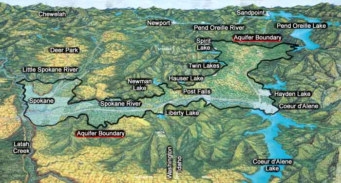
Stretching between eight or nine of those lakes is the Rathdrum Prairie, part of a 370 square mile trench gouged out between the Selkirk and Bitterroot ranges and planed flat by a glacier.

About a dozen miles long and a dozen wide, it then elbows west across the border to Spokane, Washington.

But this Prairie, which discovered in the 1950s as the perfect place to grow grass seed, had been created 15,000 years ago by a series of floods after the 3,000 sq. mile Lake Missoula broke through an ice sheet dam sending a wall of water 2,000 feet high gushing down its length and beyond, clear to California.

The Cordilleran Ice Sheet, which held one and a half times what Antarctica does today or did until recently, also melted very fast leaving Northern Idaho’s spectacular, natural mountain lakes as remnants, 75 overall within 50 miles of Spokane.

I was reminded of that sweaty, dusty, round-the-clock work harvesting grass seed when I recently learned by trial and error that the ridgeline where I live a mile and a fourth from Downtown Durham, NC is apparently on the cusp of climate change.

Kentucky Bluegrass seed such I harvested is used to grow turf up in the mountains here.  But until recently, it has been fescue that ruled around Durham, including 10% of my city lot covered by four strips of lawn to slow runoff from my house and natural areas.

The battle lines for climate change apparently run between Durham and Raleigh, where the Piedmont falls away to the Coastal Plain, which has also been, until recently, a sort of demarcation line as well between “cool” and “warm” season grasses.

The year before last when heat and fungus overwhelmed my turf, I tried to jump ahead of the curve by replacing the fescue with what was touted as a cold tolerant Zoysia turf, as a few institutions and homeowners did.

Of course, grass is not always grown from seed even in North Carolina.  Tall fescue and Kentucky Bluegrass began and still are pasture grasses.

Back when I was a teenager, as the tall grass ripened,  big swathers, (aka windrowers) were used to cut the grass where it lay drying in the field for about a week or more.

Then several staggered combines ran down the rows without stopping while processing the seed into trucks.  Outgrowing teenagers, all of the equipment used today seems two or three times larger than back then.

Zoysia, which is primarily grown from plugs, is purely ornamental.

And as it seems the case with everything, there are now heritage or heirloom varieties of seed being grown.

But sod growers have a varied clientele.  In North Carolina, tall fescue sod is grown by 40% of sod growers compared to 25% who grow Kentucky Bluegrass.  Warm season grasses such as Bermuda and Zoysia are grown by 75% and 80% respectively.

Only 12.3% overall goes to homeowners while 63% goes to landscape contractors, 9% to golf courses, 7.6% to athletic fields and 4% to retail garden centers.

Lawns didn’t begin with the invention of the lawn mower.  They moved from pasture to homes in the 1500s during the Renaissance in France and England.

Both U.S. Presidents Washington and Jefferson had lawns.  They became fixtures around ranches and later farms for the same reason they had in Europe.

But it was the leisure activity of lawn bowling that had brought lawns to America by 1650.  By the 1850s, lawns were used to create meadows in urban parks, followed by golf courses by the 1870s.

The first lawnmower was invented in 1830 in England.  A reel mower was patented in the U.S. in 1868.  By 1890, they were a fixture of landscapes and by 1914 gasoline-powered mowers were available.

Even riding lawn mowers date to 1922.

But the lawn mower became truly mainstream in 1946 when soldiers returned from WWII and bought homes created for them in the suburbs.

That year, two years before I was born, 140,000 mowers were sold.  By the time I was three years old, 1.2 million mowers a year were sold in the U.S and lawns had become a fixture around farm and ranch houses as well.

By the time I turned ten in 1958, 4.2 million were sold annually, and using ours to cut neighbors lawns became one of my first part time jobs away from home.

Still, the majority of grass seed is for non-residential use.  There are nearly 50,000 square miles of lawn across America, about the equivalent of the entire state of North Carolina and more than irrigated crops such as corn and wheat.

When I worked part time to combine it in Idaho during the mid-1960s, grass seed was dry farmed.  Back then, as it had been since the 1950s, the stubble was burned after harvesting.

There are other ways to manage stubble including baling and selling it for feed but since 2007 but due, in part, to burning the number of Kentucky Bluegrass farms in Idaho has fallen by 55% and fescue growers by 40% as they have nationwide.

That practice came under increased scrutiny for air pollution until 2007 when as a result of a court case, the state of Idaho began to regulate burning of harvested grass fields except on tribal lands.

This involved permitting, burn management training and a $2 per acre fee to burn, as well as identification of no-burn days calibrated to atmospheric conditions especially near population centers such as Spokane.

Apparently Americans now spend $40 billion a year on lawn care.  However, NASA scientists believe that under conditions such as recycling grass clippings, lawns are a carbon sink, meaning they sequester harmful gases causing climate change.

But the real issue is water.  Over half (56) of North Carolina’s 100 counties are at risk for water shortages which nation-wide studies show will be aggravated by climate change.

Unlike Durham which began to invest heavily to build its own reservoirs in the late 1920s when the population was fewer than 50,000 people, less than 20% the size it is today, many counties waited for state and federal assistance, which dried up long ago.

In Idaho, which relies on melting snow, the percentage of counties at risk for water shortages is 64%, in part, due to overuse of the Snake River aquifer.  In other mountain states such as Utah it is 72%.

In Texas, it is 98%.  A quick calculation suggests there is a correlation between red states and water shortages.

But climate change, as it already has in North Carolina, is shifting growing zones north and west while creating drier, less arable micro-climates in some parts of the country.

This will also increase pest and noxious weed populations, all of which will create more pressure for burning as a crop management tool.  It will also lead to a return to dry farming rather than irrigation, resulting in more burning.

Dry farming is natural to one-third of the earth’s land surface.  Mormons heading west in 1847 learned it from Native Americans who had been practicing it in that region for hundreds of years.

At Fort Laramie, a stop on the trail, they also saw it being experimented with to grow wheat for provisioning along the Oregon-Mormon trail.  It is how we grew feed crops on our ancestral cattle and horse ranch west of the Henry’s Fork in the Yellowstone nook of Idaho.

Following a fifty year period when irrigation technology has depleted aquifers across the nation, 12 million acres of cultivation in the West has reverted to dry farming.

It was the technique that was used where I was harvesting grass seed forty-eight years ago even though Northern Idaho sits atop an aquifer, it has twice as much rainfall as Southern Idaho.

Look for dry farming to continue its comeback.