Showing posts with label Tetons. Show all posts

Monday, December 08, 2014

A Backdoor Influence on Sensibilities

When they learn that I grew up just outside of Yellowstone Park in the Idaho shadows of the Tetons, people usually ask me when the best time is to visit.

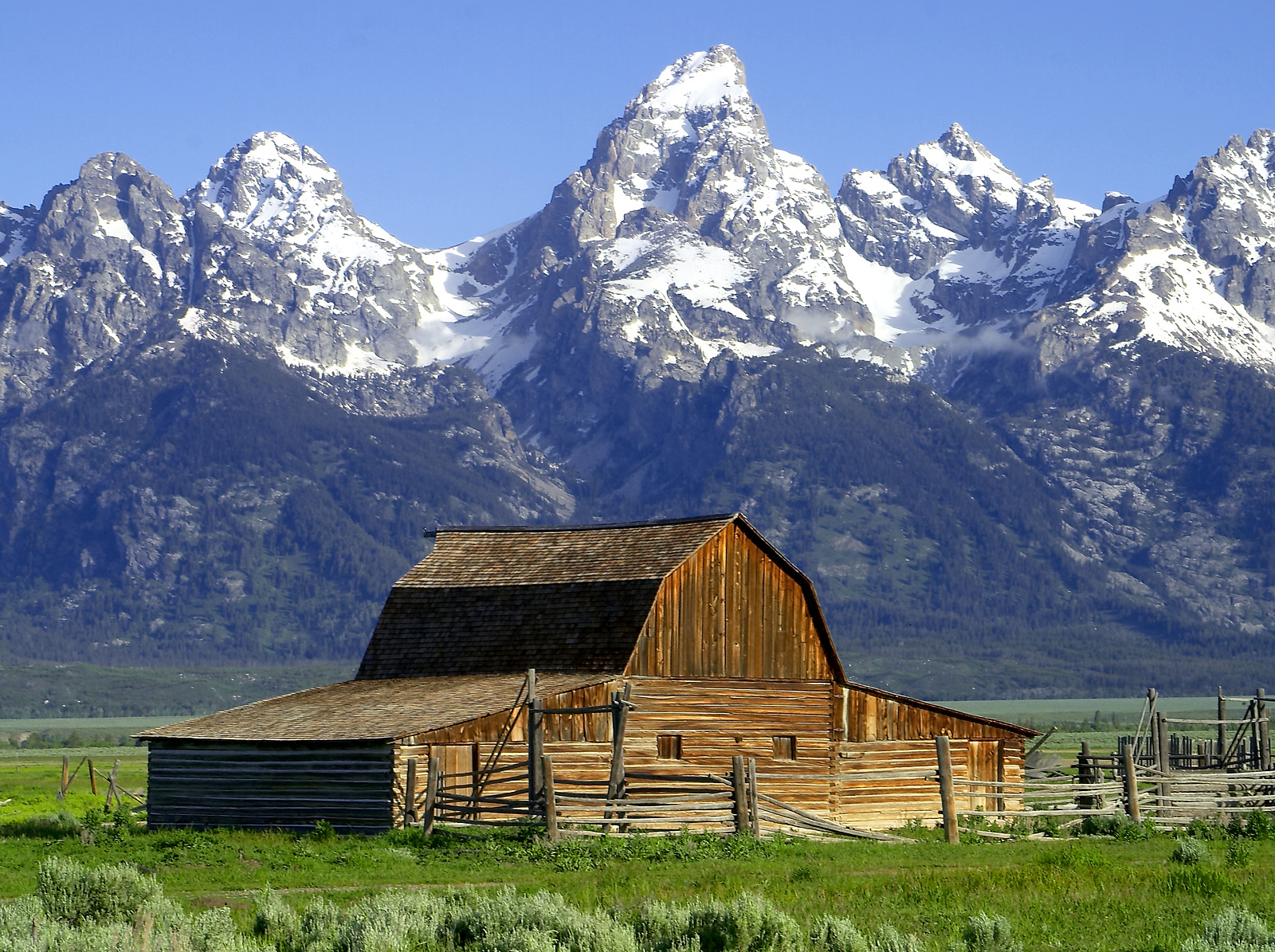
Views of those icons were readily available literally from the front yard because our ranch house, a log home built by my grandfather’s brother, faces that direction,

They mesmerized me each morning as I waited out by the mail box for the school bus.

But early influences on my appreciation of sense of place were just as likely to be to the west of the ranch which had a strikingly different landscape.  But before I get to that, let me respond with two answers to that question about the best time to visit Yellowstone.

My top-of-mind answer about the best time to visit is “fall” which was my favorite season to go there growing up.  But possibly the very best time of year to see wildlife now such as moose, bear, buffalo, elk and wolves, is in the winter.

Until 1948, the year I was born, there had been only a few snowshoe tourists in Yellowstone.  But that year the first snow planes entered the park.  Our neighbor and father of one of my schoolmates had one similar to the one shown in this video.

By the time I was in second grade, visitors toured Yellowstone in the winter aboard Bombardier R12s, mini-buses with skis (instead of tires) in front and tracks in back. 

Very cool and yes, this is the very same company that makes very cool business, and commercial jets and high-speed trains.

It took root back in the 1930s when 15-year-old J.A. Bombardier began invention of these vehicles in the years before snowplowing of rural roads was mandated in his native Quebec, Canada.

I was that age before the first snowmobiles entered the park which soon became a problem that has led to limitations, in part, to preserve tourism quality for all concerned.

Snowcoaches today are much quieter and far more comfortable but not far removed from those old R12s.

My earliest roots in Idaho go back to 1860 and creation of the first permanent settlement there.  This was more than a decade before Yellowstone Park was created and before Idaho was even a territory.

How we came to be located much further north in that nook of Idaho even traces to that period, when one of my great-great grandfathers was a “freighter” to the gold fields in Montana, meaning he drove a stage coach designed to carry supplies up that 250 mile route.

But that is for another post.  Lets just say I am as Idaho as it gets.

Many of my sense of place influences there were also formed when I ventured west out the back of that ranch house during unstructured exploration and play time on old buggies, a deserted Power-Wagon and in abandoned ancestral houses including treasure-filled landfills.

I was also drawn further along a nearly hundred mile stretch to the west beyond the hills and meadows of our rangeland, through a landscape that was much more subtle but just as dramatic as the much closer Tetons and Yellowstone were to the east.

The ranch lies along the cusp of a sagebrush steppe west of the Tetons.  Eight miles west just and beyond our rangeland was the northern reach of a towering range of sand dunes that stretched southwest parallel to the Henry’s Fork River, past St. Anthony where my grandparents lived to the Egin Bench.

By towering, I mean that some of the dunes reach 250+ feet.  They are a mini-Sahara.  There was even a resort and swimming pool at the time but I think they got buried as the sand dunes migrated up against a series of mini-volcanoes called the Juniper Buttes.

Between the ranch and those dunes is the refuge for Elk I have written about.  They winter there before migrating past the ranch and back into a remote Idaho corner of Yellowstone to summer.

On the other side of the dunes lies the Camas National Wildlife Refuge, created in 1937 as a resting place for 50,000 migratory ducks and 3,000 geese.

Basalt columns underlie this entire region.  Our ancestral ranch lies at the intersection of where the Northern Rockies and the Teton Range of the Central Rockies meet.

The steppes slope gently down before rising in elevation past the refuge to meet other fingers of the Northern Rockies stretching southeast out into Snake River Plain.

One of those fingers is the Lost River Range, about a hundred miles west of the ranch and midway to one up between Stanley and Challis, owned until recently by singer-songwriter Carole King.

Two namesake rivers, the Big Lost River and the Little Lost River run down each side of this range, which contains the highest peaks in Idaho.

They are named “lost” because they abruptly disappear into a “sink,” recharging the vast Snake River Aquifer, a giant underground river.  Opposite 12,668 ft Borah Peak on the east side of this “sink” is a pre-historic archeological site called Wasden.

Here, when I was beginning my senior in high school just 29 miles east and more interested in music such as Satisfaction, Help and California Dreamin , Idaho archeologists uncovered thousands of prehistoric artifacts in caves created by collapsed lava tubes.

All I knew is that we had a record early snowfall that September but scientists now date the finds at the Wasden caves as between 10,000 and 12,000 years B.P. (before the present.)

Sixty miles southwest of the caves along American Falls Reservoir, archeologists from ISU just uncovered the skeleton of a 70,000-year-old Mammoth.

Just to the southwest of that “sink” along the mountains and stretching down to just above the reservoir, for nearly 15,000 years, there have been eight eruptive periods or lava flows that lasted anywhere from a few years to a few hundred years and spaced between by 2,000 years of calm.

This area lies along an alternative route that wagons along the Oregon Trail took called Goodale’s Cutoff beginning a few years after my Idaho roots were first established and almost two decades after my ancestors settled west along the Rockies.

Wagon trains didn’t end with the completion of the first transcontinental railroad in 1869.  They continued along that route until 1900 when they finally gave way to the motor vehicle era.

In 1926, Republican President Calvin Coolidge set this eerie tract of eruption aside as the Craters of the Moon National Monument and Preserve.  In preparation for landing on the moon, Apollo astronauts visited the area in 1969 to study its mosaic of flows, splatter cones, craters, monoliths and other Moon-like geologic features.

It wasn’t the first time the area would be used for research.  The area immediately northwest of the monument had been used during WWII as a proving ground by the Navy to sight-in battleship guns and by the Army for testing munitions and for bombing practice.

Then after the war, it was chosen as a site for research on the first atomic submarine including a prototype for the USS Nautilus.  This is also where crews for atomic subs were sent for training until the mid-1990s.  Yup, in Idaho.

In fact, that isn’t the full extent of land-locked Idaho’s naval prowess.

Further north in the Idaho Rockies, the Navy also had a training station for other ships during WWII at Farragut on Lake Pend Oreille.

By then a state park, the year I started my community marketing career in Spokane and my only child was born, Farragut was the site of the 1973 National Boy Scout jamboree.

But even today, at a more remote part of that huge lake, the Navy tests acoustics down 1,000 feet or more using huge scale models of submarines.  Yup, in Idaho.

Sorry to get sidetracked onto research but you can see what I mean when I say that the influence my native state has on my appreciation for sense of places, goes far beyond its spectacular rivers, mountains, lakes and parks.

So anytime you cut through that part of Idaho on I-15 running north-south between Idaho Falls and Dillon, midway between the Teton and the Lost River ranges, if you find yourself complaining that it just seems like miles and miles of sage brush, take a detour for a closer look.

Thursday, February 13, 2014

The Rocks of My Ages

Just west of Rawlins, Wyoming is where most modern day travelers first cross the Continental Divide which stretches from Alaska’s Bering Strait in the Arctic Ocean to the Straits of Magellan off the southern tip of South America.

It is a hydrological designation, where water flows west on one side and east on the other.

Geologists believe rock outcroppings west of Rawlins cover a greater spread of time than any other between the two coasts, well over half the existence of the earth.  This translates to twenty-six hundred years, ten times older than those exposed in the Grand Canyon.

These outcroppings break like waves from the end of the Wind River Range, where all but one of my sixteen great-great grandparents banked southeast through a break in the Rockies on wagon trains in the late 1840s and early 1850s.

Several were among the first Mormons along that route but by then 2,500 others had preceded them in what would become the western migration of some 300,000 who would follow.

What distinguished my ancestors is that they stopped along the trail to make it easier for those who followed by building ferry crossings and supply depots.

Half of my great-grandparents colonized settlements along mountains, framing each side of the Salt Lake and Utah valleys as well as west-central Nevada and northern and central Arizona.

The other half turned north to settle Cache Valley where it straddles what is now the Utah and Idaho border before eventually migrating north to homestead and ranch the upper reaches of the Henry’s Fork along the Idaho side of the Tetons in a nook between Montana and Wyoming.

The northern branches could have saved a lot of time if they had cut 200 miles northwest along the Wind River Range to Jackson Hole and then over the Tetons.  Both areas were shown on maps and in pamphlets published by Congress a few years earlier to share the results of expeditions led by John C. Frémont.

Frémont’s route up the Wind River Range and then across the Tetons to my homeland is one of my favorite drives.  The iconic Tetons are only 40 miles long and less than ten miles wide.

This is only 13 miles longer than the distance from my long-time home of Durham, North Carolina southeast to Raleigh and a width similar to the distance from Durham southwest to Chapel Hill.

Yet the Tetons are not only the backdrop to my origins but by far the most frequently used image to symbolize the west.  They are used more than any other backdrop, often shown on the horizon of movie depictions of the 1,500 mile route my ancestors took west as the great migration began.

Several ancestors, I have learned doing family history research, became interpreters to various nations of Native Americans along the route, including the Shoshone, who are believed to have evolved from solitary family units to bands when they moved to horseback by 1700.

Having traded with Spanish explorers for their mounts, by 1700 they were trading with the Comanche near those ancient outcroppings.  Then the Shoshone traded horses to other Shoshone in Cache Valley and north with the Bannock, a Paiute-speaking nation living among the Shoshone in what is now eastern Idaho.

The Shoshone had also traded horses to the Blackfeet nation in Montana by 1751, a tribe that then used their mounts to drive the Shoshone back over the mountains framing the place of my birth in that nook of Idaho.

By the time, my ancestors moved among the Shoshone as interpreters, the horse-mounted bands had extinguished vast Buffalo herds in eastern Idaho from that Teton nook down to Cache Valley.

Trappers from the east often used the term “hole” to refer to a valley rimmed by mountains, e.g. Jackson Hole, Henry’s Hole and Pierre’s Hole.  The term was picked up by outlaws, cattlemen and homesteaders.

The forty-mile valleys on each side of the Tetons are remarkably flat in contrast to the explosive 7,000 foot sheerness of that range rising abruptly on each side from the valley floors, which are already a mile above sea level.

On the Idaho side, the valley was leveled out by volcanic lava flows.  On the Wyoming side, the valley was scoured flat by a glacier a half a mile thick.  On the Idaho side, springs feed the North Fork of the Snake River.  On the Wyoming side, they feed the South Fork.

Together the two forks join downstream to form the powerful Snake River near Idaho Falls.

Geologists, according to John McPhee in his book Rising from the Plains, believe that the Teton landscape provides not only the most complete geologic history in North America but the most complex.

For me, they symbolize my roots.  Along with Mt. McKinley, which I could view from my office in Anchorage, Monument Valley and the Grand Canyon, the Tetons are known as America’s scenic climax.

To me, they symbolize my beginning.

Friday, January 14, 2011

Defusing Bombs

One night last October, I found myself waiting for a dinner order at a restaurant bar in Cheyenne, Wyoming, seated between a two men in their late twenties.  One was a club hockey player from Canada, in route with his team to Colorado for a game, and the other I learned was a person desperate for a new career.

“I lost my job in the gas fields up near Pinedale because Obama was elected,” he declared.  I gently reminded him that the economy collapsed under the previous President and he nodded yes with a sudden epiphany.43_unexploded_sea_bomb

Something about him reminded me of my father.  The entire population of Wyoming is no more than the population of the Durham, North Carolina metro area where I live.

He was surprised that I knew where Pinedale was until I revealed that I had grown up on the other side of the Teton Range about the same distance west as Pinedale is southeast of Jackson Hole.

I could tell, even if he hadn’t explained, that he was one of many young people in that part of the country who had married soon after high school, got a good job and started a family only to have his dreams bombed by the financial industry meltdown that none of us truly grasps.

Life isn’t always “fair” and it is likely President Obama is not only blamed by a lot of people for the meltdown, and ironically, probably won’t receive credit by those same people for the turnaround.

I asked the guy at the bar what brought him all the way down to Cheyenne and he told me “bombs.”  His father-in-law had paid for him to take a training course and be certified to “defuse and dispose of bombs” in numerous places around the world.

He wasn’t going to move but he knew he’d never again be able to enjoy, in the same way, the simple pleasures Pinedale gives a sportsman.  He knew he’d miss his wife and kids every day but he was eager to feel useful again, to see the world and to do something to help people.

I told him, “now you’ll have skills and training in two industries”, but something in his eyes told me that he’d never be going back to the gas fields.  I thought back over our conversation as I walked back to my hotel room across a parking lot filled with vehicles and out-of-state hunters readying to follow me in the morning up over the 9,000+ foot Laramie Pass -- I to visit my grandsons in Salt Lake City and the hunters seeking trophy Elk.

I hope everyone who’s life has been altered by this recession can share in some way that young man’s resilience, his lack of bitterness, his humility and courage to pursue a completely different career and his heartfelt gratitude for assistance.

I just wish he could lend his new skill at defusing bombs to regulators in the Federal government who are tasked with making certain that another meltdown like this doesn’t recur at a time when so many new to Congress seem bent on rolling back and short-funding new safeguards including consumer protections.

Friday, August 13, 2010

Where The Tetons Lean “Left!”

A hero of mine is Emanuel J. “Mutt” Evans. He was Jewish and elected Mayor of my adopted home of Durham North Carolina from 1951 – 1963, guiding the community through desegregation.

My favorite story about Mayor Evans is when a Judge ordered him to segregate seating at his downtown lunch counter, he just took out all of the seats, letting people comingle. He was obviously very “Durham.”Tetons From the Idaho Side

But you’ll never guess which State was first to elect a Jewish Governor? Pivotal word is “elect” (earlier a Jewish person had become Governor of Georgia through resignation.)

Yup, my birth state of Idaho. As it it is today, from well before statehood, Idaho has always seemed very “Republican” politically, maybe in allegiance to President Abraham Lincoln, under whom it first became a territory.

It is ironic then that the State has produced a number of famous Progressive/Liberal politicians on both sides of the aisle, such as Republican William Borah and Democrat Frank Church. And shortly after statehood in 1890, Boise, the capitol elected a Jewish mayor, Moses Alexander (he had already served two terms as a mayor of a town in Missouri.)

In 1915, elected as a Progressive Democrat, Governor Alexander was seated in the first of two terms as Governor of the State of Idaho, a decade or so after my family homesteaded a ranch and farm over in the Teton-Yellowstone corner.

By the way, you can always tell the “Idaho” side of the Tetons because they curve “left,” I’m sure, just to remind the Gem state that some of its greatest elected leaders have leaned in that direction.